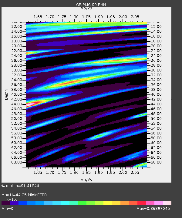
PMG IRIS/GEOFON/PACIFIC21 Station Port Moresby, PNG - Earthquake Result Viewer

Earthquake location: Off E. Coast Of N. Island, N.Z.
Earthquake latitude/longitude: -37.1/179.0
Earthquake time(UTC): 2001/10/21 (294) 00:29:21 GMT
Earthquake Depth: 18 km
Earthquake Magnitude: 6.0 MB, 6.8 MS, 6.7 MW, 6.6 MW
Earthquake Catalog/Contributor: WHDF/NEIC
Network: GE GEOFON
Station: PMG IRIS/GEOFON/PACIFIC21 Station Port Moresby, PNG
Lat/Lon: 9.41 S/147.15 E
Elevation: 67 m
Distance: 39.9 deg
Az: 305.718 deg
Baz: 138.887 deg
Ray Param: 0.07471448
Estimated Moho Depth: 44.25 km
Estimated Crust Vp/Vs: 1.60
Assumed Crust Vp: 6.122 km/s
Estimated Crust Vs: 3.826 km/s
Estimated Crust Poisson's Ratio: 0.18
Radial Match: 91.41846 %
Radial Bump: 400
Transverse Match: 73.96705 %
Transverse Bump: 400
SOD ConfigId: 20082
Insert Time: 2010-03-09 05:49:17.072 +0000
GWidth: 2.5
Max Bumps: 400
Tol: 0.001

Signal To Noise

ChannelStoNSTALTA
GE:PMG:00:BHN:20011021T00:36:23.173014Z3.6110412.2291482E-76.1731456E-8
GE:PMG:00:BHE:20011021T00:36:23.173014Z3.93373352.56794E-76.527998E-8
GE:PMG:00:BHZ:20011021T00:36:23.173014Z9.8036288.8998496E-79.0781185E-8
Arrivals
Ps4.7 SECOND
PpPs18 SECOND
PsPs/PpSs22 SECOND