You are here: Home > Network List > GE - GEOFON Stations List
> Station PMG IRIS/GEOFON/PACIFIC21 Station Port Moresby, PNG > Earthquake Result Viewer
PMG IRIS/GEOFON/PACIFIC21 Station Port Moresby, PNG - Earthquake Result Viewer
| Earthquake location: |
Mariana Islands Region |
| Earthquake latitude/longitude: |
21.6/143.0 |
| Earthquake time(UTC): |
2001/07/03 (184) 13:10:42 GMT |
| Earthquake Depth: |
290 km |
| Earthquake Magnitude: |
6.0 MB, 6.5 MW, 6.5 MW |
| Earthquake Catalog/Contributor: |
WHDF/NEIC |
|
| Network: |
GE GEOFON |
| Station: |
PMG IRIS/GEOFON/PACIFIC21 Station Port Moresby, PNG |
| Lat/Lon: |
9.41 S/147.15 E |
| Elevation: |
67 m |
|
| Distance: |
31.1 deg |
| Az: |
172.022 deg |
| Baz: |
352.48 deg |
| Ray Param: |
0.07825809 |
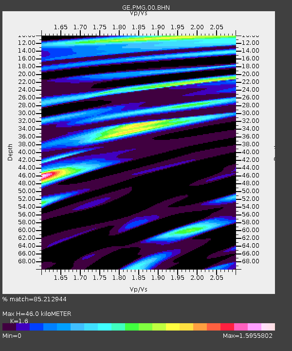
| Estimated Moho Depth: |
46.0 km |
| Estimated Crust Vp/Vs: |
1.60 |
| Assumed Crust Vp: |
6.122 km/s |
| Estimated Crust Vs: |
3.826 km/s |
| Estimated Crust Poisson's Ratio: |
0.18 |
|
| Radial Match: |
85.212944 % |
| Radial Bump: |
400 |
| Transverse Match: |
72.52901 % |
| Transverse Bump: |
400 |
| SOD ConfigId: |
20082 |
| Insert Time: |
2010-03-09 05:49:18.596 +0000 |
| GWidth: |
2.5 |
| Max Bumps: |
400 |
| Tol: |
0.001 |
|

Signal To Noise
| Channel | StoN | STA | LTA |
| GE:PMG:00:BHN:20010703T13:16:04.37301Z | 5.736608 | 1.2113305E-6 | 2.1115798E-7 |
| GE:PMG:00:BHE:20010703T13:16:04.37301Z | 2.8687792 | 5.0413684E-7 | 1.7573217E-7 |
| GE:PMG:00:BHZ:20010703T13:16:04.37301Z | 13.492791 | 2.2690554E-6 | 1.6816799E-7 |
| Arrivals |
| Ps | 4.9 SECOND |
| PpPs | 18 SECOND |
| PsPs/PpSs | 23 SECOND |


