You are here: Home > Network List > AK - Alaska Regional Network Stations List
> Station F21K Alatna River, AK, USA > Earthquake Result Viewer
F21K Alatna River, AK, USA - Earthquake Result Viewer
| Earthquake location: |
Greece |
| Earthquake latitude/longitude: |
39.8/22.2 |
| Earthquake time(UTC): |
2021/03/03 (062) 10:16:10 GMT |
| Earthquake Depth: |
10 km |
| Earthquake Magnitude: |
6.3 Mww |
| Earthquake Catalog/Contributor: |
NEIC PDE/us |
|
| Network: |
AK Alaska Regional Network |
| Station: |
F21K Alatna River, AK, USA |
| Lat/Lon: |
67.22 N/153.48 W |
| Elevation: |
597 m |
|
| Distance: |
73.3 deg |
| Az: |
358.236 deg |
| Baz: |
3.493 deg |
| Ray Param: |
0.05310309 |
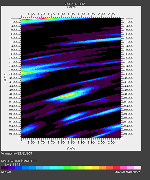
| Estimated Moho Depth: |
10.0 km |
| Estimated Crust Vp/Vs: |
1.64 |
| Assumed Crust Vp: |
6.455 km/s |
| Estimated Crust Vs: |
3.942 km/s |
| Estimated Crust Poisson's Ratio: |
0.20 |
|
| Radial Match: |
82.81809 % |
| Radial Bump: |
400 |
| Transverse Match: |
74.75305 % |
| Transverse Bump: |
400 |
| SOD ConfigId: |
23341671 |
| Insert Time: |
2021-03-17 11:19:48.940 +0000 |
| GWidth: |
2.5 |
| Max Bumps: |
400 |
| Tol: |
0.001 |
|

Signal To Noise
| Channel | StoN | STA | LTA |
| AK:F21K: :BHZ:20210303T10:27:10.379983Z | 3.374815 | 5.0805477E-7 | 1.50543E-7 |
| AK:F21K: :BHN:20210303T10:27:10.379983Z | 0.60271263 | 9.6510895E-8 | 1.6012754E-7 |
| AK:F21K: :BHE:20210303T10:27:10.379983Z | 1.238476 | 1.5411497E-7 | 1.2443921E-7 |
| Arrivals |
| Ps | 1.0 SECOND |
| PpPs | 3.9 SECOND |
| PsPs/PpSs | 5.0 SECOND |


