You are here: Home > Network List > IW - Intermountain West Stations List
> Station MOOW Moose Ponds, Wyoming, USA > Earthquake Result Viewer
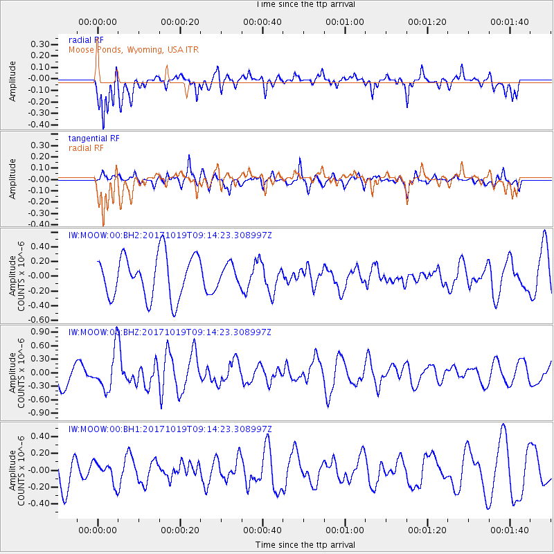
MOOW Moose Ponds, Wyoming, USA - Earthquake Result Viewer
*The percent match for this event was below the threshold and hence no stack was calculated.
| Earthquake location: |
Southeast Of Ryukyu Islands |
| Earthquake latitude/longitude: |
28.3/131.2 |
| Earthquake time(UTC): |
2017/10/19 (292) 09:02:01 GMT |
| Earthquake Depth: |
10 km |
| Earthquake Magnitude: |
5.8 Mww |
| Earthquake Catalog/Contributor: |
NEIC PDE/us |
|
| Network: |
IW Intermountain West |
| Station: |
MOOW Moose Ponds, Wyoming, USA |
| Lat/Lon: |
43.75 N/110.74 W |
| Elevation: |
2128 m |
|
| Distance: |
88.6 deg |
| Az: |
39.773 deg |
| Baz: |
308.896 deg |
| Ray Param: |
$rayparam |
*The percent match for this event was below the threshold and hence was not used in the summary stack. |
|
| Radial Match: |
60.813026 % |
| Radial Bump: |
400 |
| Transverse Match: |
53.83447 % |
| Transverse Bump: |
400 |
| SOD ConfigId: |
2364251 |
| Insert Time: |
2017-11-02 09:05:44.719 +0000 |
| GWidth: |
2.5 |
| Max Bumps: |
400 |
| Tol: |
0.001 |
|
Signal To Noise
| Channel | StoN | STA | LTA |
| IW:MOOW:00:BHZ:20171019T09:14:23.308997Z | 1.7208098 | 4.4740943E-7 | 2.5999935E-7 |
| IW:MOOW:00:BH1:20171019T09:14:23.308997Z | 0.5580832 | 1.2412892E-7 | 2.2242008E-7 |
| IW:MOOW:00:BH2:20171019T09:14:23.308997Z | 0.4657644 | 1.3489496E-7 | 2.8962057E-7 |
| Arrivals |
| Ps | |
| PpPs | |
| PsPs/PpSs | |


