You are here: Home > Network List > TA - USArray Transportable Network (new EarthScope stations) Stations List
> Station E23K Chandalar, AK, USA > Earthquake Result Viewer
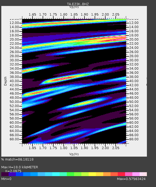
E23K Chandalar, AK, USA - Earthquake Result Viewer
| Earthquake location: |
Greece |
| Earthquake latitude/longitude: |
39.8/22.2 |
| Earthquake time(UTC): |
2021/03/03 (062) 10:16:10 GMT |
| Earthquake Depth: |
10 km |
| Earthquake Magnitude: |
6.3 Mww |
| Earthquake Catalog/Contributor: |
NEIC PDE/us |
|
| Network: |
TA USArray Transportable Network (new EarthScope stations) |
| Station: |
E23K Chandalar, AK, USA |
| Lat/Lon: |
68.06 N/149.62 W |
| Elevation: |
1084 m |
|
| Distance: |
72.3 deg |
| Az: |
356.772 deg |
| Baz: |
6.632 deg |
| Ray Param: |
0.05374026 |
| Estimated Moho Depth: |
18.0 km |
| Estimated Crust Vp/Vs: |
2.10 |
| Assumed Crust Vp: |
6.316 km/s |
| Estimated Crust Vs: |
3.011 km/s |
| Estimated Crust Poisson's Ratio: |
0.35 |
|
| Radial Match: |
86.18118 % |
| Radial Bump: |
400 |
| Transverse Match: |
77.754234 % |
| Transverse Bump: |
400 |
| SOD ConfigId: |
23341671 |
| Insert Time: |
2021-03-17 11:35:13.449 +0000 |
| GWidth: |
2.5 |
| Max Bumps: |
400 |
| Tol: |
0.001 |
|

Signal To Noise
| Channel | StoN | STA | LTA |
| TA:E23K: :BHZ:20210303T10:27:04.675027Z | 1.9854779 | 4.907637E-7 | 2.471766E-7 |
| TA:E23K: :BHN:20210303T10:27:04.675027Z | 1.4644306 | 2.2133345E-7 | 1.511396E-7 |
| TA:E23K: :BHE:20210303T10:27:04.675027Z | 0.5949416 | 1.17907845E-7 | 1.9818388E-7 |
| Arrivals |
| Ps | 3.2 SECOND |
| PpPs | 8.6 SECOND |
| PsPs/PpSs | 12 SECOND |


