You are here: Home > Network List > TA - USArray Transportable Network (new EarthScope stations) Stations List
> Station E29M Blow River, YT, CAN > Earthquake Result Viewer
E29M Blow River, YT, CAN - Earthquake Result Viewer
| Earthquake location: |
Greece |
| Earthquake latitude/longitude: |
39.8/22.2 |
| Earthquake time(UTC): |
2021/03/03 (062) 10:16:10 GMT |
| Earthquake Depth: |
10 km |
| Earthquake Magnitude: |
6.3 Mww |
| Earthquake Catalog/Contributor: |
NEIC PDE/us |
|
| Network: |
TA USArray Transportable Network (new EarthScope stations) |
| Station: |
E29M Blow River, YT, CAN |
| Lat/Lon: |
68.39 N/137.90 W |
| Elevation: |
324 m |
|
| Distance: |
71.1 deg |
| Az: |
352.332 deg |
| Baz: |
16.118 deg |
| Ray Param: |
0.054520104 |
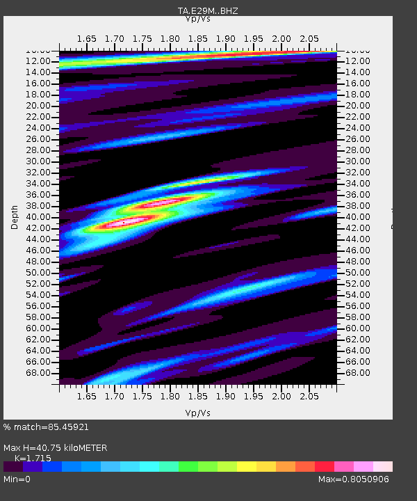
| Estimated Moho Depth: |
40.75 km |
| Estimated Crust Vp/Vs: |
1.72 |
| Assumed Crust Vp: |
5.981 km/s |
| Estimated Crust Vs: |
3.488 km/s |
| Estimated Crust Poisson's Ratio: |
0.24 |
|
| Radial Match: |
85.45921 % |
| Radial Bump: |
400 |
| Transverse Match: |
76.01364 % |
| Transverse Bump: |
398 |
| SOD ConfigId: |
23341671 |
| Insert Time: |
2021-03-17 11:35:15.687 +0000 |
| GWidth: |
2.5 |
| Max Bumps: |
400 |
| Tol: |
0.001 |
|

Signal To Noise
| Channel | StoN | STA | LTA |
| TA:E29M: :BHZ:20210303T10:26:57.550027Z | 4.2482247 | 8.190792E-7 | 1.9280506E-7 |
| TA:E29M: :BHN:20210303T10:26:57.550027Z | 1.4332803 | 2.6659788E-7 | 1.860054E-7 |
| TA:E29M: :BHE:20210303T10:26:57.550027Z | 1.4241033 | 3.6560002E-7 | 2.5672298E-7 |
| Arrivals |
| Ps | 5.0 SECOND |
| PpPs | 18 SECOND |
| PsPs/PpSs | 23 SECOND |


