You are here: Home > Network List > US - United States National Seismic Network Stations List
> Station MNTX Cornudas Mountains, Texas, USA > Earthquake Result Viewer
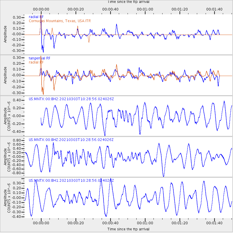
MNTX Cornudas Mountains, Texas, USA - Earthquake Result Viewer
*The percent match for this event was below the threshold and hence no stack was calculated.
| Earthquake location: |
Greece |
| Earthquake latitude/longitude: |
39.8/22.2 |
| Earthquake time(UTC): |
2021/03/03 (062) 10:16:10 GMT |
| Earthquake Depth: |
10 km |
| Earthquake Magnitude: |
6.3 Mww |
| Earthquake Catalog/Contributor: |
NEIC PDE/us |
|
| Network: |
US United States National Seismic Network |
| Station: |
MNTX Cornudas Mountains, Texas, USA |
| Lat/Lon: |
31.70 N/105.38 W |
| Elevation: |
404 m |
|
| Distance: |
93.9 deg |
| Az: |
317.37 deg |
| Baz: |
37.765 deg |
| Ray Param: |
$rayparam |
*The percent match for this event was below the threshold and hence was not used in the summary stack. |
|
| Radial Match: |
76.43085 % |
| Radial Bump: |
384 |
| Transverse Match: |
59.529 % |
| Transverse Bump: |
373 |
| SOD ConfigId: |
23341671 |
| Insert Time: |
2021-03-17 11:38:24.543 +0000 |
| GWidth: |
2.5 |
| Max Bumps: |
400 |
| Tol: |
0.001 |
|
Signal To Noise
| Channel | StoN | STA | LTA |
| US:MNTX:00:BHZ:20210303T10:28:56.024026Z | 2.5088334 | 4.5786933E-7 | 1.8250289E-7 |
| US:MNTX:00:BH1:20210303T10:28:56.024026Z | 1.3934605 | 1.8024838E-7 | 1.2935305E-7 |
| US:MNTX:00:BH2:20210303T10:28:56.024026Z | 1.3142997 | 2.248189E-7 | 1.7105604E-7 |
| Arrivals |
| Ps | |
| PpPs | |
| PsPs/PpSs | |


