You are here: Home > Network List > AV - Alaska Volcano Observatory Stations List
> Station DT1 Dutton Round Hill, Mount Dutton, Alaska > Earthquake Result Viewer
DT1 Dutton Round Hill, Mount Dutton, Alaska - Earthquake Result Viewer
| Earthquake location: |
Off E. Coast Of N. Island, N.Z. |
| Earthquake latitude/longitude: |
-37.6/179.5 |
| Earthquake time(UTC): |
2021/03/04 (063) 13:27:35 GMT |
| Earthquake Depth: |
10 km |
| Earthquake Magnitude: |
6.9 mww |
| Earthquake Catalog/Contributor: |
NEIC PDE/us |
|
| Network: |
AV Alaska Volcano Observatory |
| Station: |
DT1 Dutton Round Hill, Mount Dutton, Alaska |
| Lat/Lon: |
55.11 N/162.28 W |
| Elevation: |
198 m |
|
| Distance: |
93.6 deg |
| Az: |
10.348 deg |
| Baz: |
194.376 deg |
| Ray Param: |
0.041224487 |
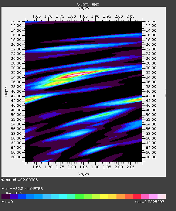
| Estimated Moho Depth: |
32.5 km |
| Estimated Crust Vp/Vs: |
1.83 |
| Assumed Crust Vp: |
5.989 km/s |
| Estimated Crust Vs: |
3.282 km/s |
| Estimated Crust Poisson's Ratio: |
0.29 |
|
| Radial Match: |
92.08385 % |
| Radial Bump: |
400 |
| Transverse Match: |
79.95222 % |
| Transverse Bump: |
400 |
| SOD ConfigId: |
23341671 |
| Insert Time: |
2021-03-18 14:29:50.248 +0000 |
| GWidth: |
2.5 |
| Max Bumps: |
400 |
| Tol: |
0.001 |
|

Signal To Noise
| Channel | StoN | STA | LTA |
| AV:DT1: :BHZ:20210304T13:40:20.058988Z | 5.227172 | 2.4777949E-6 | 4.7402207E-7 |
| AV:DT1: :BHN:20210304T13:40:20.058988Z | 3.6945133 | 9.309914E-7 | 2.51993E-7 |
| AV:DT1: :BHE:20210304T13:40:20.058988Z | 0.7769609 | 2.7153388E-7 | 3.4948204E-7 |
| Arrivals |
| Ps | 4.6 SECOND |
| PpPs | 15 SECOND |
| PsPs/PpSs | 20 SECOND |


