You are here: Home > Network List > C1 - Red Sismologica Nacional Stations List
> Station VA01 Torpederas > Earthquake Result Viewer
VA01 Torpederas - Earthquake Result Viewer
| Earthquake location: |
Off E. Coast Of N. Island, N.Z. |
| Earthquake latitude/longitude: |
-37.6/179.5 |
| Earthquake time(UTC): |
2021/03/04 (063) 13:27:35 GMT |
| Earthquake Depth: |
10 km |
| Earthquake Magnitude: |
6.9 mww |
| Earthquake Catalog/Contributor: |
NEIC PDE/us |
|
| Network: |
C1 Red Sismologica Nacional |
| Station: |
VA01 Torpederas |
| Lat/Lon: |
33.02 S/71.64 W |
| Elevation: |
2.0 m |
|
| Distance: |
83.4 deg |
| Az: |
126.827 deg |
| Baz: |
229.183 deg |
| Ray Param: |
0.04619136 |
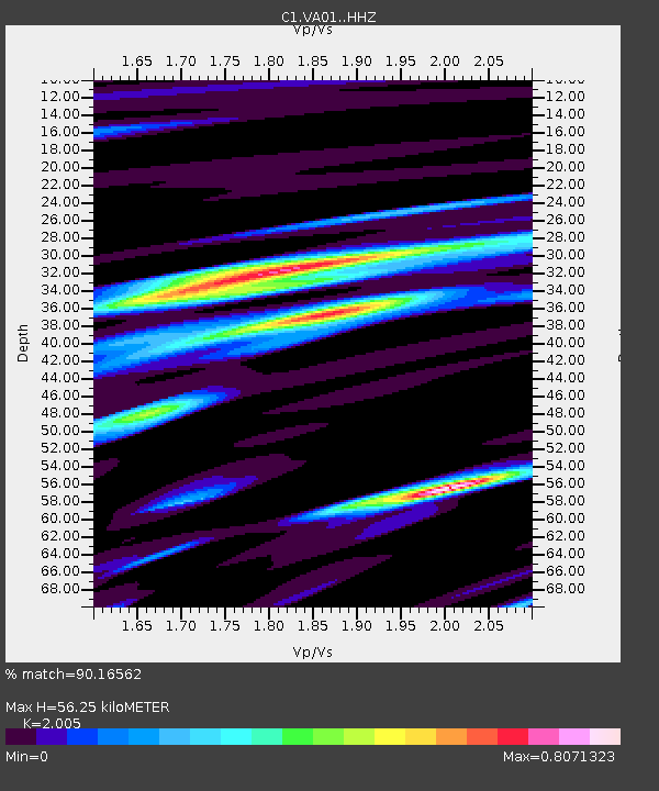
| Estimated Moho Depth: |
56.25 km |
| Estimated Crust Vp/Vs: |
2.01 |
| Assumed Crust Vp: |
6.481 km/s |
| Estimated Crust Vs: |
3.232 km/s |
| Estimated Crust Poisson's Ratio: |
0.33 |
|
| Radial Match: |
90.16562 % |
| Radial Bump: |
400 |
| Transverse Match: |
78.082695 % |
| Transverse Bump: |
400 |
| SOD ConfigId: |
23341671 |
| Insert Time: |
2021-03-18 14:33:09.984 +0000 |
| GWidth: |
2.5 |
| Max Bumps: |
400 |
| Tol: |
0.001 |
|

Signal To Noise
| Channel | StoN | STA | LTA |
| C1:VA01: :HHZ:20210304T13:39:31.339994Z | 10.62476 | 3.7495086E-6 | 3.529029E-7 |
| C1:VA01: :HHN:20210304T13:39:31.339994Z | 3.7933354 | 1.0979568E-6 | 2.8944365E-7 |
| C1:VA01: :HHE:20210304T13:39:31.339994Z | 2.9007652 | 9.633635E-7 | 3.3210665E-7 |
| Arrivals |
| Ps | 8.9 SECOND |
| PpPs | 25 SECOND |
| PsPs/PpSs | 34 SECOND |


