You are here: Home > Network List > HV - Hawaiian Volcano Observatory Network Stations List
> Station HAT Halemaumau Trail > Earthquake Result Viewer
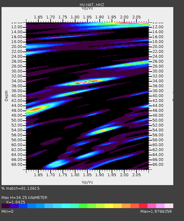
HAT Halemaumau Trail - Earthquake Result Viewer
| Earthquake location: |
Off E. Coast Of N. Island, N.Z. |
| Earthquake latitude/longitude: |
-37.6/179.5 |
| Earthquake time(UTC): |
2021/03/04 (063) 13:27:35 GMT |
| Earthquake Depth: |
10 km |
| Earthquake Magnitude: |
6.9 mww |
| Earthquake Catalog/Contributor: |
NEIC PDE/us |
|
| Network: |
HV Hawaiian Volcano Observatory Network |
| Station: |
HAT Halemaumau Trail |
| Lat/Lon: |
19.42 N/155.26 W |
| Elevation: |
1097 m |
|
| Distance: |
61.5 deg |
| Az: |
27.212 deg |
| Baz: |
202.635 deg |
| Ray Param: |
0.06084779 |
| Estimated Moho Depth: |
34.25 km |
| Estimated Crust Vp/Vs: |
1.84 |
| Assumed Crust Vp: |
5.195 km/s |
| Estimated Crust Vs: |
2.82 km/s |
| Estimated Crust Poisson's Ratio: |
0.29 |
|
| Radial Match: |
81.10615 % |
| Radial Bump: |
400 |
| Transverse Match: |
75.45475 % |
| Transverse Bump: |
400 |
| SOD ConfigId: |
23341671 |
| Insert Time: |
2021-03-18 14:35:38.493 +0000 |
| GWidth: |
2.5 |
| Max Bumps: |
400 |
| Tol: |
0.001 |
|

Signal To Noise
| Channel | StoN | STA | LTA |
| HV:HAT: :HHZ:20210304T13:37:20.834013Z | 4.65857 | 6.5037952E-6 | 1.3960927E-6 |
| HV:HAT: :HHN:20210304T13:37:20.834013Z | 1.1931286 | 3.9443507E-6 | 3.305889E-6 |
| HV:HAT: :HHE:20210304T13:37:20.834013Z | 0.7572521 | 2.864755E-6 | 3.783093E-6 |
| Arrivals |
| Ps | 5.7 SECOND |
| PpPs | 18 SECOND |
| PsPs/PpSs | 24 SECOND |


