You are here: Home > Network List > UW - Pacific Northwest Regional Seismic Network Stations List
> Station YACT Amboy, WA, USA > Earthquake Result Viewer
YACT Amboy, WA, USA - Earthquake Result Viewer
| Earthquake location: |
Off E. Coast Of N. Island, N.Z. |
| Earthquake latitude/longitude: |
-37.6/179.5 |
| Earthquake time(UTC): |
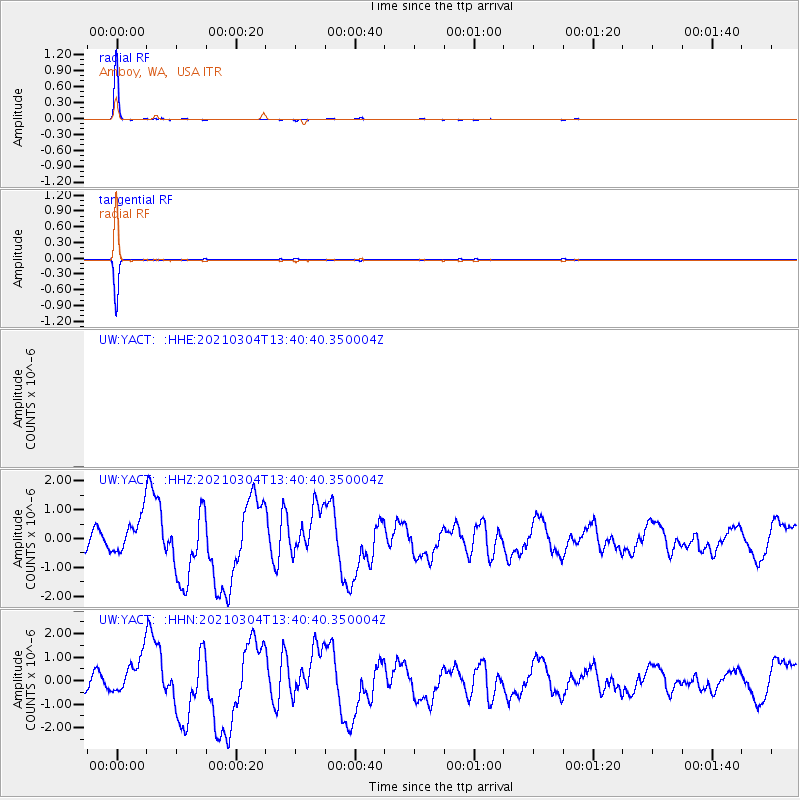
2021/03/04 (063) 13:27:35 GMT |
| Earthquake Depth: |
10 km |
| Earthquake Magnitude: |
6.9 mww |
| Earthquake Catalog/Contributor: |
NEIC PDE/us |
|
| Network: |
UW Pacific Northwest Regional Seismic Network |
| Station: |
YACT Amboy, WA, USA |
| Lat/Lon: |
45.93 N/122.42 W |
| Elevation: |
211 m |
|
| Distance: |
98.1 deg |
| Az: |
36.736 deg |
| Baz: |
222.902 deg |
| Ray Param: |
0.039996397 |
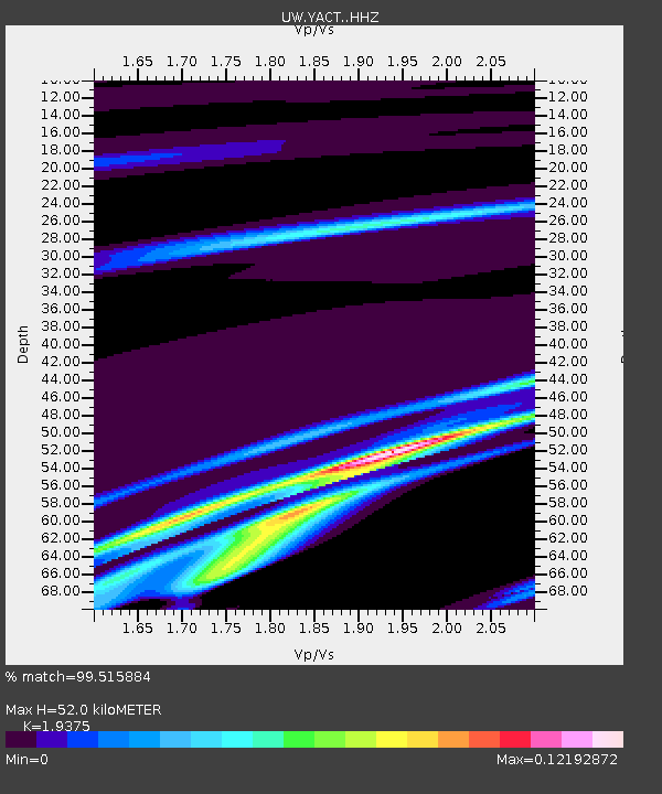
| Estimated Moho Depth: |
52.0 km |
| Estimated Crust Vp/Vs: |
1.94 |
| Assumed Crust Vp: |
6.566 km/s |
| Estimated Crust Vs: |
3.389 km/s |
| Estimated Crust Poisson's Ratio: |
0.32 |
|
| Radial Match: |
99.515884 % |
| Radial Bump: |
40 |
| Transverse Match: |
99.51589 % |
| Transverse Bump: |
40 |
| SOD ConfigId: |
23341671 |
| Insert Time: |
2021-03-18 14:39:53.777 +0000 |
| GWidth: |
2.5 |
| Max Bumps: |
400 |
| Tol: |
0.001 |
|
Signal To Noise
| Channel | StoN | STA | LTA |
| UW:YACT: :HHZ:20210304T13:40:40.350004Z | 3.923782 | 6.50413E-7 | 1.6576176E-7 |
| UW:YACT: :HHN:20210304T13:40:40.350004Z | 3.838024 | 8.1512957E-7 | 2.1238262E-7 |
| $trig.getChannelId() | $trig.getValue() | $trig.getSTA() | $trig.getLTA() |
| Arrivals |
| Ps | 7.6 SECOND |
| PpPs | 23 SECOND |
| PsPs/PpSs | 30 SECOND |


