You are here: Home > Network List > IW - Intermountain West Stations List
> Station DLMT Dillon, Montana, USA > Earthquake Result Viewer
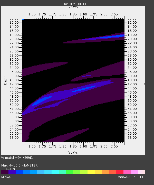
DLMT Dillon, Montana, USA - Earthquake Result Viewer
| Earthquake location: |
Southeast Of Loyalty Islands |
| Earthquake latitude/longitude: |
-23.1/171.9 |
| Earthquake time(UTC): |
2021/03/04 (063) 14:10:36 GMT |
| Earthquake Depth: |
10 km |
| Earthquake Magnitude: |
5.6 mb |
| Earthquake Catalog/Contributor: |
NEIC PDE/us |
|
| Network: |
IW Intermountain West |
| Station: |
DLMT Dillon, Montana, USA |
| Lat/Lon: |
45.36 N/112.60 W |
| Elevation: |
1569 m |
|
| Distance: |
96.6 deg |
| Az: |
43.407 deg |
| Baz: |
243.84 deg |
| Ray Param: |
0.040478773 |
| Estimated Moho Depth: |
10.0 km |
| Estimated Crust Vp/Vs: |
1.60 |
| Assumed Crust Vp: |
6.577 km/s |
| Estimated Crust Vs: |
4.111 km/s |
| Estimated Crust Poisson's Ratio: |
0.18 |
|
| Radial Match: |
94.49961 % |
| Radial Bump: |
382 |
| Transverse Match: |
91.23332 % |
| Transverse Bump: |
400 |
| SOD ConfigId: |
23341671 |
| Insert Time: |
2021-03-18 15:18:50.810 +0000 |
| GWidth: |
2.5 |
| Max Bumps: |
400 |
| Tol: |
0.001 |
|

Signal To Noise
| Channel | StoN | STA | LTA |
| IW:DLMT:00:BHZ:20210304T14:23:34.919989Z | 1.6479359 | 2.4927876E-5 | 1.5126728E-5 |
| IW:DLMT:00:BH1:20210304T14:23:34.919989Z | 1.360953 | 8.429313E-6 | 6.1936844E-6 |
| IW:DLMT:00:BH2:20210304T14:23:34.919989Z | 0.9656725 | 1.0116939E-5 | 1.0476574E-5 |
| Arrivals |
| Ps | 0.9 SECOND |
| PpPs | 3.9 SECOND |
| PsPs/PpSs | 4.8 SECOND |


