You are here: Home > Network List > UW - Pacific Northwest Regional Seismic Network Stations List
> Station STOR Enumclaw, WA, USA > Earthquake Result Viewer
STOR Enumclaw, WA, USA - Earthquake Result Viewer

| Earthquake location: |
Southeast Of Loyalty Islands |
| Earthquake latitude/longitude: |
-23.1/171.9 |
| Earthquake time(UTC): |
2021/03/04 (063) 14:10:36 GMT |
| Earthquake Depth: |
10 km |
| Earthquake Magnitude: |
5.6 mb |
| Earthquake Catalog/Contributor: |
NEIC PDE/us |
|
| Network: |
UW Pacific Northwest Regional Seismic Network |
| Station: |
STOR Enumclaw, WA, USA |
| Lat/Lon: |
47.19 N/121.99 W |
| Elevation: |
266 m |
|
| Distance: |
91.8 deg |
| Az: |
38.615 deg |
| Baz: |
237.415 deg |
| Ray Param: |
0.041561194 |
| Estimated Moho Depth: |
67.0 km |
| Estimated Crust Vp/Vs: |
1.60 |
| Assumed Crust Vp: |
6.597 km/s |
| Estimated Crust Vs: |
4.123 km/s |
| Estimated Crust Poisson's Ratio: |
0.18 |
|
| Radial Match: |
87.72551 % |
| Radial Bump: |
400 |
| Transverse Match: |
65.77207 % |
| Transverse Bump: |
400 |
| SOD ConfigId: |
23341671 |
| Insert Time: |
2021-03-18 15:23:04.273 +0000 |
| GWidth: |
2.5 |
| Max Bumps: |
400 |
| Tol: |
0.001 |
|
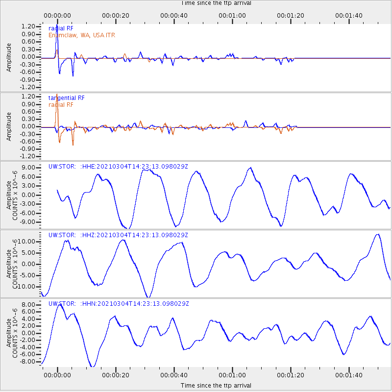
Signal To Noise
| Channel | StoN | STA | LTA |
| UW:STOR: :HHZ:20210304T14:23:13.098029Z | 1.2623847 | 6.942092E-6 | 5.4991892E-6 |
| UW:STOR: :HHN:20210304T14:23:13.098029Z | 1.6735868 | 7.0051124E-6 | 4.185688E-6 |
| UW:STOR: :HHE:20210304T14:23:13.098029Z | 1.6933001 | 8.908036E-6 | 5.2607543E-6 |
| Arrivals |
| Ps | 6.2 SECOND |
| PpPs | 26 SECOND |
| PsPs/PpSs | 32 SECOND |


