You are here: Home > Network List > MM - Myanmar National Seismic Network Stations List
> Station TGI Taung Gyi, Myanmar > Earthquake Result Viewer
TGI Taung Gyi, Myanmar - Earthquake Result Viewer
| Earthquake location: |
Vanuatu Islands |
| Earthquake latitude/longitude: |
-14.4/167.3 |
| Earthquake time(UTC): |
2021/03/04 (063) 16:53:11 GMT |
| Earthquake Depth: |
172 km |
| Earthquake Magnitude: |
6.1 Mww |
| Earthquake Catalog/Contributor: |
NEIC PDE/us |
|
| Network: |
MM Myanmar National Seismic Network |
| Station: |
TGI Taung Gyi, Myanmar |
| Lat/Lon: |
20.77 N/97.03 E |
| Elevation: |
1458 m |
|
| Distance: |
77.4 deg |
| Az: |
295.486 deg |
| Baz: |
110.854 deg |
| Ray Param: |
0.04995062 |
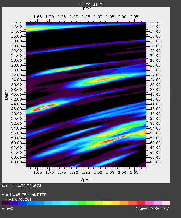
| Estimated Moho Depth: |
45.25 km |
| Estimated Crust Vp/Vs: |
1.67 |
| Assumed Crust Vp: |
6.316 km/s |
| Estimated Crust Vs: |
3.782 km/s |
| Estimated Crust Poisson's Ratio: |
0.22 |
|
| Radial Match: |
90.036674 % |
| Radial Bump: |
400 |
| Transverse Match: |
74.48439 % |
| Transverse Bump: |
400 |
| SOD ConfigId: |
23341671 |
| Insert Time: |
2021-03-18 18:03:01.746 +0000 |
| GWidth: |
2.5 |
| Max Bumps: |
400 |
| Tol: |
0.001 |
|

Signal To Noise
| Channel | StoN | STA | LTA |
| MM:TGI: :HHZ:20210304T17:04:15.960003Z | 8.672992 | 8.731152E-7 | 1.006706E-7 |
| MM:TGI: :HHN:20210304T17:04:15.960003Z | 2.0559242 | 2.3061531E-7 | 1.12171115E-7 |
| MM:TGI: :HHE:20210304T17:04:15.960003Z | 2.6986504 | 3.1328165E-7 | 1.16088266E-7 |
| Arrivals |
| Ps | 5.0 SECOND |
| PpPs | 19 SECOND |
| PsPs/PpSs | 23 SECOND |


