You are here: Home > Network List > TA - USArray Transportable Network (new EarthScope stations) Stations List
> Station G16K Koyuk River, AK, USA > Earthquake Result Viewer
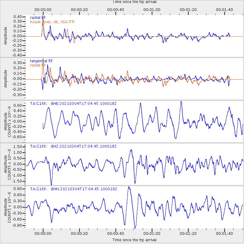
G16K Koyuk River, AK, USA - Earthquake Result Viewer
*The percent match for this event was below the threshold and hence no stack was calculated.
| Earthquake location: |
Vanuatu Islands |
| Earthquake latitude/longitude: |
-14.4/167.3 |
| Earthquake time(UTC): |
2021/03/04 (063) 16:53:11 GMT |
| Earthquake Depth: |
172 km |
| Earthquake Magnitude: |
6.1 Mww |
| Earthquake Catalog/Contributor: |
NEIC PDE/us |
|
| Network: |
TA USArray Transportable Network (new EarthScope stations) |
| Station: |
G16K Koyuk River, AK, USA |
| Lat/Lon: |
65.39 N/162.35 W |
| Elevation: |
169 m |
|
| Distance: |
82.8 deg |
| Az: |
12.312 deg |
| Baz: |
209.562 deg |
| Ray Param: |
$rayparam |
*The percent match for this event was below the threshold and hence was not used in the summary stack. |
|
| Radial Match: |
52.56966 % |
| Radial Bump: |
331 |
| Transverse Match: |
68.05392 % |
| Transverse Bump: |
400 |
| SOD ConfigId: |
23341671 |
| Insert Time: |
2021-03-18 18:05:22.036 +0000 |
| GWidth: |
2.5 |
| Max Bumps: |
400 |
| Tol: |
0.001 |
|
Signal To Noise
| Channel | StoN | STA | LTA |
| TA:G16K: :BHZ:20210304T17:04:45.100018Z | 2.2002015 | 6.873358E-7 | 3.1239674E-7 |
| TA:G16K: :BHN:20210304T17:04:45.100018Z | 1.2343789 | 3.3938906E-7 | 2.749472E-7 |
| TA:G16K: :BHE:20210304T17:04:45.100018Z | 0.9613563 | 2.648073E-7 | 2.7545178E-7 |
| Arrivals |
| Ps | |
| PpPs | |
| PsPs/PpSs | |


