You are here: Home > Network List > TA - USArray Transportable Network (new EarthScope stations) Stations List
> Station I17K Unalakleet, AK, USA > Earthquake Result Viewer
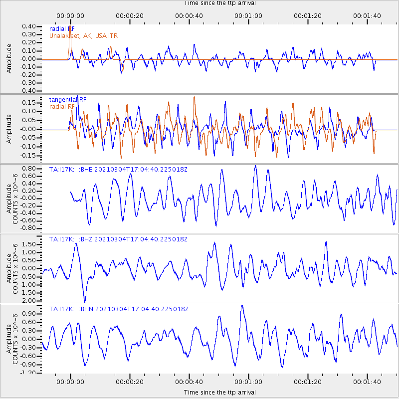
I17K Unalakleet, AK, USA - Earthquake Result Viewer
*The percent match for this event was below the threshold and hence no stack was calculated.
| Earthquake location: |
Vanuatu Islands |
| Earthquake latitude/longitude: |
-14.4/167.3 |
| Earthquake time(UTC): |
2021/03/04 (063) 16:53:11 GMT |
| Earthquake Depth: |
172 km |
| Earthquake Magnitude: |
6.1 Mww |
| Earthquake Catalog/Contributor: |
NEIC PDE/us |
|
| Network: |
TA USArray Transportable Network (new EarthScope stations) |
| Station: |
I17K Unalakleet, AK, USA |
| Lat/Lon: |
63.89 N/160.70 W |
| Elevation: |
105 m |
|
| Distance: |
81.9 deg |
| Az: |
13.706 deg |
| Baz: |
211.246 deg |
| Ray Param: |
$rayparam |
*The percent match for this event was below the threshold and hence was not used in the summary stack. |
|
| Radial Match: |
52.501263 % |
| Radial Bump: |
400 |
| Transverse Match: |
60.537518 % |
| Transverse Bump: |
400 |
| SOD ConfigId: |
23341671 |
| Insert Time: |
2021-03-18 18:05:31.612 +0000 |
| GWidth: |
2.5 |
| Max Bumps: |
400 |
| Tol: |
0.001 |
|
Signal To Noise
| Channel | StoN | STA | LTA |
| TA:I17K: :BHZ:20210304T17:04:40.225018Z | 3.1750174 | 1.0119254E-6 | 3.187149E-7 |
| TA:I17K: :BHN:20210304T17:04:40.225018Z | 1.5352776 | 4.7102668E-7 | 3.068023E-7 |
| TA:I17K: :BHE:20210304T17:04:40.225018Z | 0.8805293 | 3.0064268E-7 | 3.4143403E-7 |
| Arrivals |
| Ps | |
| PpPs | |
| PsPs/PpSs | |


