You are here: Home > Network List > US - United States National Seismic Network Stations List
> Station MNTX Cornudas Mountains, Texas, USA > Earthquake Result Viewer
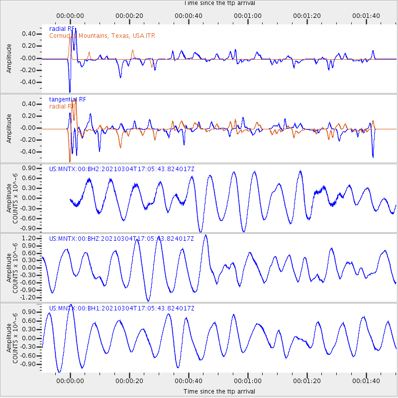
MNTX Cornudas Mountains, Texas, USA - Earthquake Result Viewer
*The percent match for this event was below the threshold and hence no stack was calculated.
| Earthquake location: |
Vanuatu Islands |
| Earthquake latitude/longitude: |
-14.4/167.3 |
| Earthquake time(UTC): |
2021/03/04 (063) 16:53:11 GMT |
| Earthquake Depth: |
172 km |
| Earthquake Magnitude: |
6.1 Mww |
| Earthquake Catalog/Contributor: |
NEIC PDE/us |
|
| Network: |
US United States National Seismic Network |
| Station: |
MNTX Cornudas Mountains, Texas, USA |
| Lat/Lon: |
31.70 N/105.38 W |
| Elevation: |
404 m |
|
| Distance: |
95.2 deg |
| Az: |
58.762 deg |
| Baz: |
256.35 deg |
| Ray Param: |
$rayparam |
*The percent match for this event was below the threshold and hence was not used in the summary stack. |
|
| Radial Match: |
73.580315 % |
| Radial Bump: |
400 |
| Transverse Match: |
85.11903 % |
| Transverse Bump: |
400 |
| SOD ConfigId: |
23341671 |
| Insert Time: |
2021-03-18 18:06:53.540 +0000 |
| GWidth: |
2.5 |
| Max Bumps: |
400 |
| Tol: |
0.001 |
|
Signal To Noise
| Channel | StoN | STA | LTA |
| US:MNTX:00:BHZ:20210304T17:05:43.824017Z | 0.9771904 | 4.2349015E-7 | 4.3337528E-7 |
| US:MNTX:00:BH1:20210304T17:05:43.824017Z | 1.9243233 | 8.451236E-7 | 4.3917964E-7 |
| US:MNTX:00:BH2:20210304T17:05:43.824017Z | 0.9255014 | 3.1006297E-7 | 3.3502164E-7 |
| Arrivals |
| Ps | |
| PpPs | |
| PsPs/PpSs | |


