You are here: Home > Network List > AK - Alaska Regional Network Stations List
> Station TGL Tana Glacier > Earthquake Result Viewer
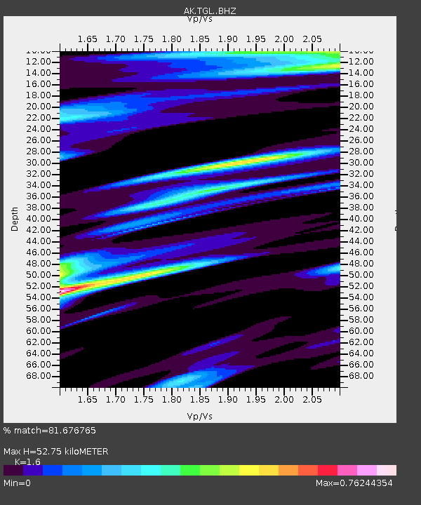
TGL Tana Glacier - Earthquake Result Viewer
| Earthquake location: |
Kermadec Islands, New Zealand |
| Earthquake latitude/longitude: |
-29.6/-177.8 |
| Earthquake time(UTC): |
2021/03/04 (063) 17:41:25 GMT |
| Earthquake Depth: |
56 km |
| Earthquake Magnitude: |
7.4 mww |
| Earthquake Catalog/Contributor: |
NEIC PDE/us |
|
| Network: |
AK Alaska Regional Network |
| Station: |
TGL Tana Glacier |
| Lat/Lon: |
60.75 N/142.83 W |
| Elevation: |
1260 m |
|
| Distance: |
94.5 deg |
| Az: |
16.417 deg |
| Baz: |
210.079 deg |
| Ray Param: |
0.041004915 |
| Estimated Moho Depth: |
52.75 km |
| Estimated Crust Vp/Vs: |
1.60 |
| Assumed Crust Vp: |
6.566 km/s |
| Estimated Crust Vs: |
4.104 km/s |
| Estimated Crust Poisson's Ratio: |
0.18 |
|
| Radial Match: |
81.676765 % |
| Radial Bump: |
400 |
| Transverse Match: |
63.155636 % |
| Transverse Bump: |
400 |
| SOD ConfigId: |
23341671 |
| Insert Time: |
2021-03-18 18:45:06.439 +0000 |
| GWidth: |
2.5 |
| Max Bumps: |
400 |
| Tol: |
0.001 |
|

Signal To Noise
| Channel | StoN | STA | LTA |
| AK:TGL: :BHZ:20210304T17:54:08.448008Z | 0.9428301 | 6.3494565E-7 | 6.734465E-7 |
| AK:TGL: :BHN:20210304T17:54:08.448008Z | 1.4954284 | 1.0685527E-6 | 7.1454616E-7 |
| AK:TGL: :BHE:20210304T17:54:08.448008Z | 1.2707999 | 3.9888502E-7 | 3.13885E-7 |
| Arrivals |
| Ps | 4.9 SECOND |
| PpPs | 20 SECOND |
| PsPs/PpSs | 25 SECOND |


