You are here: Home > Network List > AV - Alaska Volcano Observatory Stations List
> Station ADAG Mount Adagdak, Regional Station, Alaska > Earthquake Result Viewer
ADAG Mount Adagdak, Regional Station, Alaska - Earthquake Result Viewer
| Earthquake location: |
Kermadec Islands, New Zealand |
| Earthquake latitude/longitude: |
-29.6/-177.8 |
| Earthquake time(UTC): |
2021/03/04 (063) 17:41:25 GMT |
| Earthquake Depth: |
56 km |
| Earthquake Magnitude: |
7.4 mww |
| Earthquake Catalog/Contributor: |
NEIC PDE/us |
|
| Network: |
AV Alaska Volcano Observatory |
| Station: |
ADAG Mount Adagdak, Regional Station, Alaska |
| Lat/Lon: |
51.98 N/176.60 W |
| Elevation: |
281 m |
|
| Distance: |
81.2 deg |
| Az: |
0.776 deg |
| Baz: |
181.093 deg |
| Ray Param: |
0.047622528 |
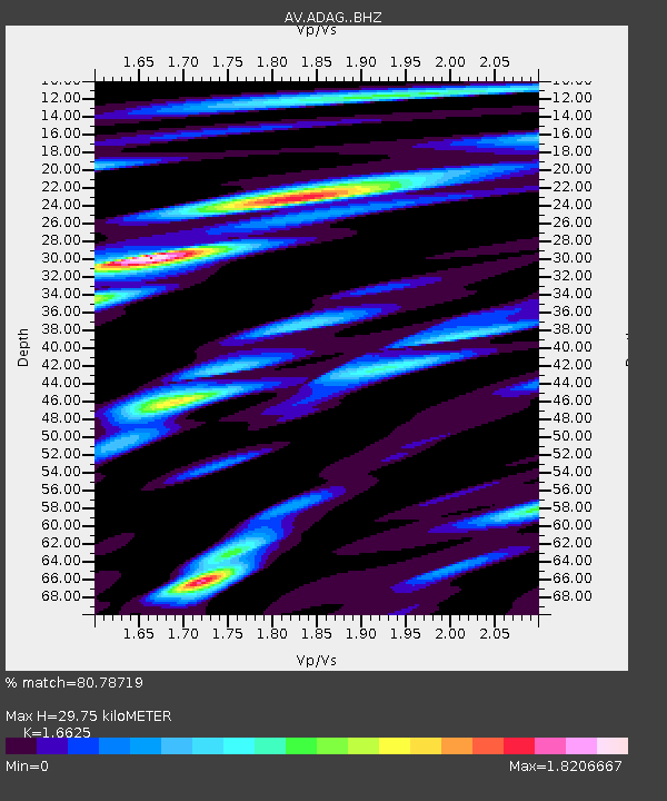
| Estimated Moho Depth: |
29.75 km |
| Estimated Crust Vp/Vs: |
1.66 |
| Assumed Crust Vp: |
5.88 km/s |
| Estimated Crust Vs: |
3.537 km/s |
| Estimated Crust Poisson's Ratio: |
0.22 |
|
| Radial Match: |
80.78719 % |
| Radial Bump: |
400 |
| Transverse Match: |
66.863556 % |
| Transverse Bump: |
400 |
| SOD ConfigId: |
23341671 |
| Insert Time: |
2021-03-18 18:46:27.596 +0000 |
| GWidth: |
2.5 |
| Max Bumps: |
400 |
| Tol: |
0.001 |
|
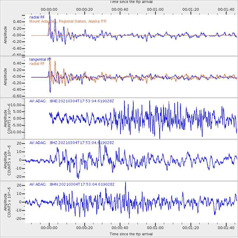
Signal To Noise
| Channel | StoN | STA | LTA |
| AV:ADAG: :BHZ:20210304T17:53:04.619028Z | 5.381463 | 5.296377E-6 | 9.84189E-7 |
| AV:ADAG: :BHN:20210304T17:53:04.619028Z | 1.5449791 | 2.9468713E-6 | 1.907386E-6 |
| AV:ADAG: :BHE:20210304T17:53:04.619028Z | 1.1315706 | 2.48902E-6 | 2.1996154E-6 |
| Arrivals |
| Ps | 3.4 SECOND |
| PpPs | 13 SECOND |
| PsPs/PpSs | 17 SECOND |


