You are here: Home > Network List > AV - Alaska Volcano Observatory Stations List
> Station MNAT Nateekin Bay, Makushin Volcano, Alaska > Earthquake Result Viewer
MNAT Nateekin Bay, Makushin Volcano, Alaska - Earthquake Result Viewer
| Earthquake location: |
Kermadec Islands, New Zealand |
| Earthquake latitude/longitude: |
-29.6/-177.8 |
| Earthquake time(UTC): |
2021/03/04 (063) 17:41:25 GMT |
| Earthquake Depth: |
56 km |
| Earthquake Magnitude: |
7.4 mww |
| Earthquake Catalog/Contributor: |
NEIC PDE/us |
|
| Network: |
AV Alaska Volcano Observatory |
| Station: |
MNAT Nateekin Bay, Makushin Volcano, Alaska |
| Lat/Lon: |
53.88 N/166.69 W |
| Elevation: |
390 m |
|
| Distance: |
83.7 deg |
| Az: |
6.618 deg |
| Baz: |
189.76 deg |
| Ray Param: |
0.045895483 |
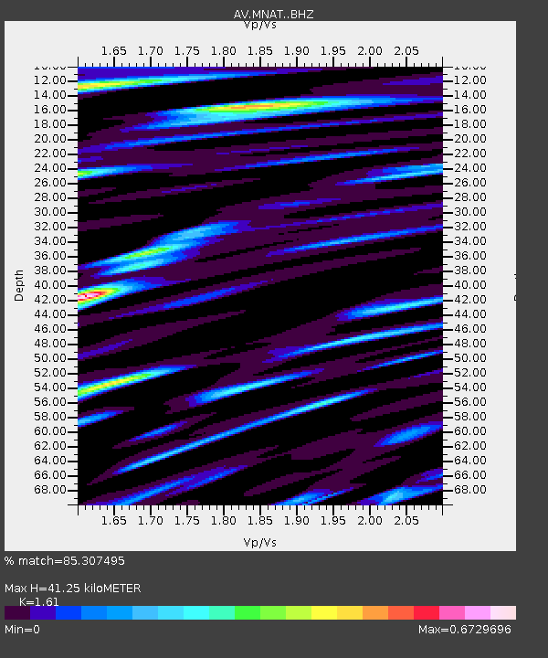
| Estimated Moho Depth: |
41.25 km |
| Estimated Crust Vp/Vs: |
1.61 |
| Assumed Crust Vp: |
3.943 km/s |
| Estimated Crust Vs: |
2.449 km/s |
| Estimated Crust Poisson's Ratio: |
0.19 |
|
| Radial Match: |
85.307495 % |
| Radial Bump: |
400 |
| Transverse Match: |
59.580036 % |
| Transverse Bump: |
400 |
| SOD ConfigId: |
23341671 |
| Insert Time: |
2021-03-18 18:47:42.325 +0000 |
| GWidth: |
2.5 |
| Max Bumps: |
400 |
| Tol: |
0.001 |
|
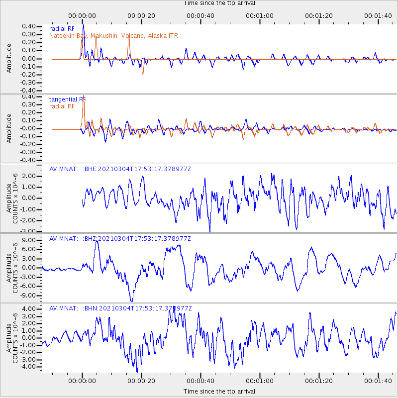
Signal To Noise
| Channel | StoN | STA | LTA |
| AV:MNAT: :BHZ:20210304T17:53:17.378977Z | 4.827759 | 3.2448759E-6 | 6.721288E-7 |
| AV:MNAT: :BHN:20210304T17:53:17.378977Z | 1.9395267 | 1.1258509E-6 | 5.8047715E-7 |
| AV:MNAT: :BHE:20210304T17:53:17.378977Z | 1.8171606 | 1.2450903E-6 | 6.8518455E-7 |
| Arrivals |
| Ps | 6.4 SECOND |
| PpPs | 27 SECOND |
| PsPs/PpSs | 33 SECOND |


