You are here: Home > Network List > AV - Alaska Volcano Observatory Stations List
> Station WESP Westdahl Peak, Westdahl Peak, Alaska > Earthquake Result Viewer
WESP Westdahl Peak, Westdahl Peak, Alaska - Earthquake Result Viewer
| Earthquake location: |
Kermadec Islands, New Zealand |
| Earthquake latitude/longitude: |
-29.6/-177.8 |
| Earthquake time(UTC): |
2021/03/04 (063) 17:41:25 GMT |
| Earthquake Depth: |
56 km |
| Earthquake Magnitude: |
7.4 mww |
| Earthquake Catalog/Contributor: |
NEIC PDE/us |
|
| Network: |
AV Alaska Volcano Observatory |
| Station: |
WESP Westdahl Peak, Westdahl Peak, Alaska |
| Lat/Lon: |
54.49 N/164.72 W |
| Elevation: |
937 m |
|
| Distance: |
84.5 deg |
| Az: |
7.644 deg |
| Baz: |
191.453 deg |
| Ray Param: |
0.045327425 |
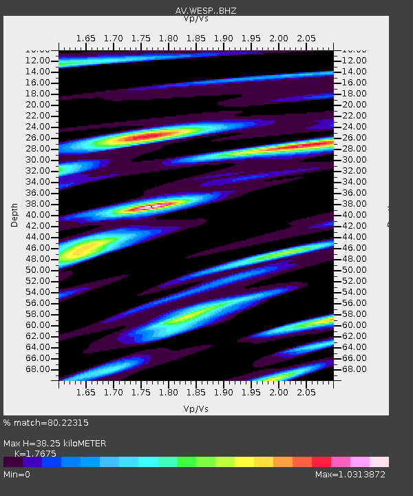
| Estimated Moho Depth: |
38.25 km |
| Estimated Crust Vp/Vs: |
1.77 |
| Assumed Crust Vp: |
5.989 km/s |
| Estimated Crust Vs: |
3.388 km/s |
| Estimated Crust Poisson's Ratio: |
0.26 |
|
| Radial Match: |
80.22315 % |
| Radial Bump: |
400 |
| Transverse Match: |
66.43022 % |
| Transverse Bump: |
400 |
| SOD ConfigId: |
23341671 |
| Insert Time: |
2021-03-18 18:48:34.273 +0000 |
| GWidth: |
2.5 |
| Max Bumps: |
400 |
| Tol: |
0.001 |
|

Signal To Noise
| Channel | StoN | STA | LTA |
| AV:WESP: :BHZ:20210304T17:53:21.50001Z | 3.2481465 | 3.7269313E-6 | 1.1474025E-6 |
| AV:WESP: :BHN:20210304T17:53:21.50001Z | 1.2075039 | 1.5361265E-6 | 1.2721503E-6 |
| AV:WESP: :BHE:20210304T17:53:21.50001Z | 0.7189744 | 1.2563382E-6 | 1.7474032E-6 |
| Arrivals |
| Ps | 5.0 SECOND |
| PpPs | 17 SECOND |
| PsPs/PpSs | 22 SECOND |


