You are here: Home > Network List > AZ - ANZA Regional Network Stations List
> Station LVA2 AZ.LVA2 > Earthquake Result Viewer
LVA2 AZ.LVA2 - Earthquake Result Viewer
| Earthquake location: |
Kermadec Islands, New Zealand |
| Earthquake latitude/longitude: |
-29.6/-177.8 |
| Earthquake time(UTC): |
2021/03/04 (063) 17:41:25 GMT |
| Earthquake Depth: |
56 km |
| Earthquake Magnitude: |
7.4 mww |
| Earthquake Catalog/Contributor: |
NEIC PDE/us |
|
| Network: |
AZ ANZA Regional Network |
| Station: |
LVA2 AZ.LVA2 |
| Lat/Lon: |
33.35 N/116.56 W |
| Elevation: |
1435 m |
|
| Distance: |
85.3 deg |
| Az: |
47.432 deg |
| Baz: |
230.015 deg |
| Ray Param: |
0.044736348 |
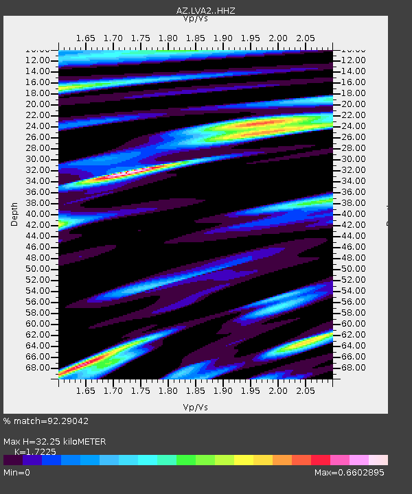
| Estimated Moho Depth: |
32.25 km |
| Estimated Crust Vp/Vs: |
1.72 |
| Assumed Crust Vp: |
6.264 km/s |
| Estimated Crust Vs: |
3.636 km/s |
| Estimated Crust Poisson's Ratio: |
0.25 |
|
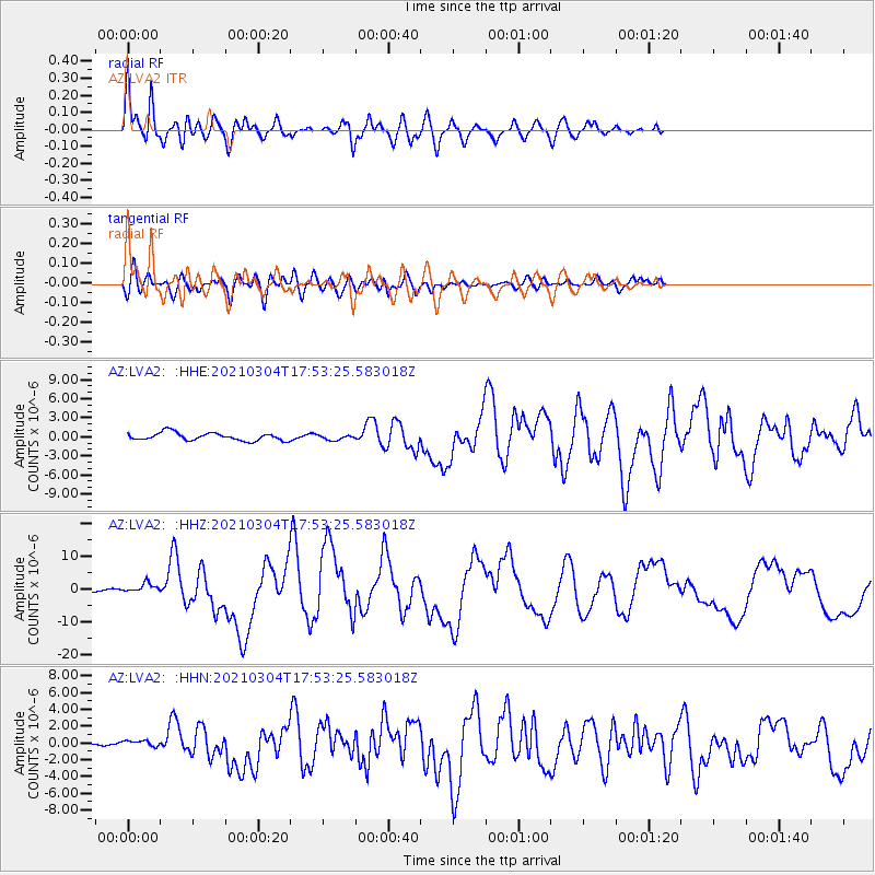
| Radial Match: |
92.29042 % |
| Radial Bump: |
400 |
| Transverse Match: |
81.08968 % |
| Transverse Bump: |
400 |
| SOD ConfigId: |
23341671 |
| Insert Time: |
2021-03-18 18:48:43.218 +0000 |
| GWidth: |
2.5 |
| Max Bumps: |
400 |
| Tol: |
0.001 |
|
Signal To Noise
| Channel | StoN | STA | LTA |
| AZ:LVA2: :HHZ:20210304T17:53:25.583018Z | 2.1975777 | 1.4723602E-6 | 6.699923E-7 |
| AZ:LVA2: :HHN:20210304T17:53:25.583018Z | 0.9205323 | 6.2667755E-7 | 6.8077736E-7 |
| AZ:LVA2: :HHE:20210304T17:53:25.583018Z | 0.6399813 | 3.883547E-7 | 6.068219E-7 |
| Arrivals |
| Ps | 3.8 SECOND |
| PpPs | 14 SECOND |
| PsPs/PpSs | 18 SECOND |


