You are here: Home > Network List > C1 - Red Sismologica Nacional Stations List
> Station BO02 Daracena > Earthquake Result Viewer
BO02 Daracena - Earthquake Result Viewer
| Earthquake location: |
Kermadec Islands, New Zealand |
| Earthquake latitude/longitude: |
-29.6/-177.8 |
| Earthquake time(UTC): |
2021/03/04 (063) 17:41:25 GMT |
| Earthquake Depth: |
56 km |
| Earthquake Magnitude: |
7.4 mww |
| Earthquake Catalog/Contributor: |
NEIC PDE/us |
|
| Network: |
C1 Red Sismologica Nacional |
| Station: |
BO02 Daracena |
| Lat/Lon: |
34.79 S/70.78 W |
| Elevation: |
886 m |
|
| Distance: |
86.0 deg |
| Az: |
127.938 deg |
| Baz: |
236.56 deg |
| Ray Param: |
0.044239692 |
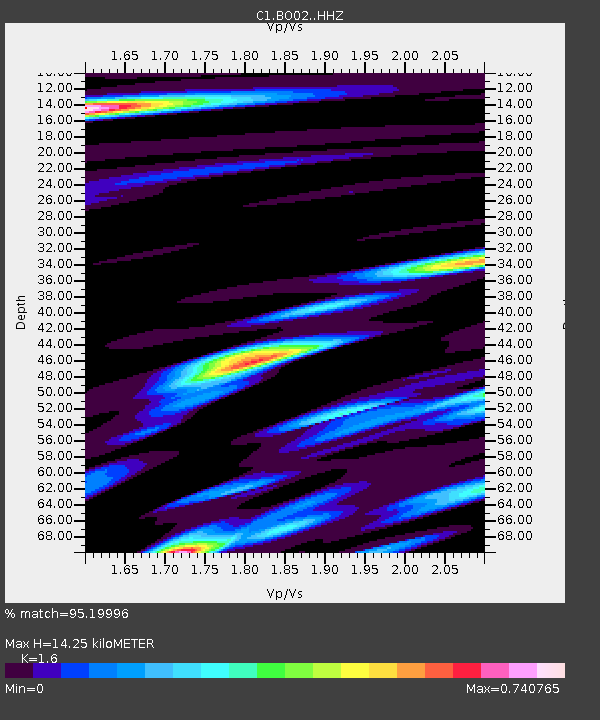
| Estimated Moho Depth: |
14.25 km |
| Estimated Crust Vp/Vs: |
1.60 |
| Assumed Crust Vp: |
6.481 km/s |
| Estimated Crust Vs: |
4.05 km/s |
| Estimated Crust Poisson's Ratio: |
0.18 |
|
| Radial Match: |
95.19996 % |
| Radial Bump: |
400 |
| Transverse Match: |
87.36175 % |
| Transverse Bump: |
400 |
| SOD ConfigId: |
23341671 |
| Insert Time: |
2021-03-18 18:49:48.012 +0000 |
| GWidth: |
2.5 |
| Max Bumps: |
400 |
| Tol: |
0.001 |
|

Signal To Noise
| Channel | StoN | STA | LTA |
| C1:BO02: :HHZ:20210304T17:53:29.047983Z | 4.945116 | 8.427408E-7 | 1.7041882E-7 |
| C1:BO02: :HHN:20210304T17:53:29.047983Z | 1.7760997 | 2.85259E-7 | 1.6060979E-7 |
| C1:BO02: :HHE:20210304T17:53:29.047983Z | 1.7638066 | 5.0051005E-7 | 2.8376698E-7 |
| Arrivals |
| Ps | 1.4 SECOND |
| PpPs | 5.6 SECOND |
| PsPs/PpSs | 6.9 SECOND |


