You are here: Home > Network List > CC - Cascade Chain Volcano Monitoring Stations List
> Station OPCH Ohanapecosh Administrative Area > Earthquake Result Viewer
OPCH Ohanapecosh Administrative Area - Earthquake Result Viewer
| Earthquake location: |
Kermadec Islands, New Zealand |
| Earthquake latitude/longitude: |
-29.6/-177.8 |
| Earthquake time(UTC): |
2021/03/04 (063) 17:41:25 GMT |
| Earthquake Depth: |
56 km |
| Earthquake Magnitude: |
7.4 mww |
| Earthquake Catalog/Contributor: |
NEIC PDE/us |
|
| Network: |
CC Cascade Chain Volcano Monitoring |
| Station: |
OPCH Ohanapecosh Administrative Area |
| Lat/Lon: |
46.73 N/121.57 W |
| Elevation: |
593 m |
|
| Distance: |
91.4 deg |
| Az: |
34.907 deg |
| Baz: |
226.422 deg |
| Ray Param: |
0.041597188 |
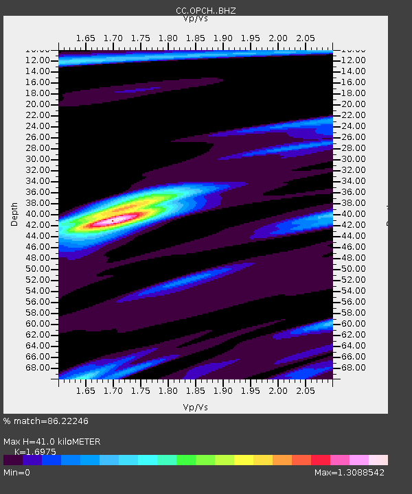
| Estimated Moho Depth: |
41.0 km |
| Estimated Crust Vp/Vs: |
1.70 |
| Assumed Crust Vp: |
6.597 km/s |
| Estimated Crust Vs: |
3.887 km/s |
| Estimated Crust Poisson's Ratio: |
0.23 |
|
| Radial Match: |
86.22246 % |
| Radial Bump: |
400 |
| Transverse Match: |
79.19919 % |
| Transverse Bump: |
400 |
| SOD ConfigId: |
23341671 |
| Insert Time: |
2021-03-18 18:50:53.697 +0000 |
| GWidth: |
2.5 |
| Max Bumps: |
400 |
| Tol: |
0.001 |
|

Signal To Noise
| Channel | StoN | STA | LTA |
| CC:OPCH: :BHZ:20210304T17:53:54.279978Z | 3.5121162 | 8.2587553E-7 | 2.351504E-7 |
| CC:OPCH: :BHN:20210304T17:53:54.279978Z | 0.7882981 | 5.4911686E-7 | 6.965853E-7 |
| CC:OPCH: :BHE:20210304T17:53:54.279978Z | 1.0370256 | 3.7636985E-7 | 3.6293207E-7 |
| Arrivals |
| Ps | 4.4 SECOND |
| PpPs | 16 SECOND |
| PsPs/PpSs | 21 SECOND |


