You are here: Home > Network List > CI - Caltech Regional Seismic Network Stations List
> Station GLA Glamis, Glamis, CA, USA > Earthquake Result Viewer
GLA Glamis, Glamis, CA, USA - Earthquake Result Viewer
| Earthquake location: |
Kermadec Islands, New Zealand |
| Earthquake latitude/longitude: |
-29.6/-177.8 |
| Earthquake time(UTC): |
2021/03/04 (063) 17:41:25 GMT |
| Earthquake Depth: |
56 km |
| Earthquake Magnitude: |
7.4 mww |
| Earthquake Catalog/Contributor: |
NEIC PDE/us |
|
| Network: |
CI Caltech Regional Seismic Network |
| Station: |
GLA Glamis, Glamis, CA, USA |
| Lat/Lon: |
33.05 N/114.83 W |
| Elevation: |
610 m |
|
| Distance: |
86.3 deg |
| Az: |
48.59 deg |
| Baz: |
231.045 deg |
| Ray Param: |
0.04407325 |
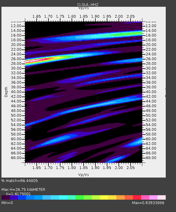
| Estimated Moho Depth: |
26.75 km |
| Estimated Crust Vp/Vs: |
1.62 |
| Assumed Crust Vp: |
6.155 km/s |
| Estimated Crust Vs: |
3.805 km/s |
| Estimated Crust Poisson's Ratio: |
0.19 |
|
| Radial Match: |
96.44805 % |
| Radial Bump: |
400 |
| Transverse Match: |
85.29285 % |
| Transverse Bump: |
400 |
| SOD ConfigId: |
23341671 |
| Insert Time: |
2021-03-18 18:51:24.206 +0000 |
| GWidth: |
2.5 |
| Max Bumps: |
400 |
| Tol: |
0.001 |
|
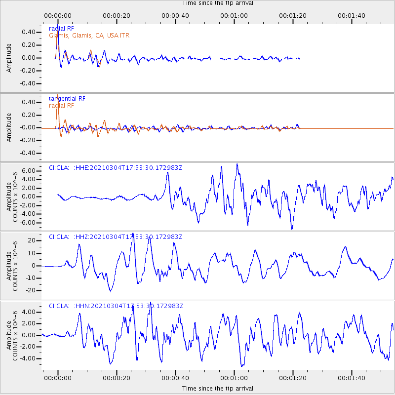
Signal To Noise
| Channel | StoN | STA | LTA |
| CI:GLA: :HHZ:20210304T17:53:30.172983Z | 4.5860176 | 1.6340222E-6 | 3.5630524E-7 |
| CI:GLA: :HHN:20210304T17:53:30.172983Z | 0.95488894 | 3.106748E-7 | 3.2535178E-7 |
| CI:GLA: :HHE:20210304T17:53:30.172983Z | 1.5122486 | 4.3371085E-7 | 2.8679864E-7 |
| Arrivals |
| Ps | 2.7 SECOND |
| PpPs | 11 SECOND |
| PsPs/PpSs | 14 SECOND |


