You are here: Home > Network List > CI - Caltech Regional Seismic Network Stations List
> Station PDM Parker Dam, Lake Havasu City, AZ, USA > Earthquake Result Viewer
PDM Parker Dam, Lake Havasu City, AZ, USA - Earthquake Result Viewer
| Earthquake location: |
Kermadec Islands, New Zealand |
| Earthquake latitude/longitude: |
-29.6/-177.8 |
| Earthquake time(UTC): |
2021/03/04 (063) 17:41:25 GMT |
| Earthquake Depth: |
56 km |
| Earthquake Magnitude: |
7.4 mww |
| Earthquake Catalog/Contributor: |
NEIC PDE/us |
|
| Network: |
CI Caltech Regional Seismic Network |
| Station: |
PDM Parker Dam, Lake Havasu City, AZ, USA |
| Lat/Lon: |
34.30 N/114.14 W |
| Elevation: |
144 m |
|
| Distance: |
87.5 deg |
| Az: |
47.974 deg |
| Baz: |
231.39 deg |
| Ray Param: |
0.043184254 |
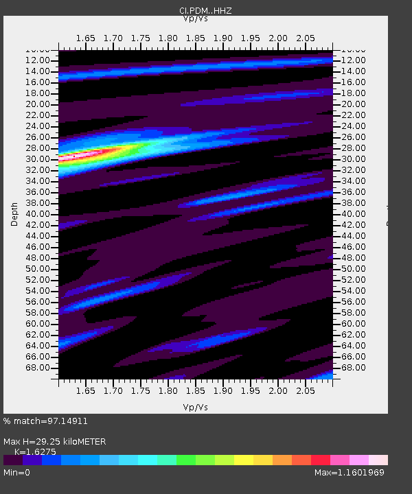
| Estimated Moho Depth: |
29.25 km |
| Estimated Crust Vp/Vs: |
1.63 |
| Assumed Crust Vp: |
6.276 km/s |
| Estimated Crust Vs: |
3.856 km/s |
| Estimated Crust Poisson's Ratio: |
0.20 |
|
| Radial Match: |
97.14911 % |
| Radial Bump: |
400 |
| Transverse Match: |
86.886215 % |
| Transverse Bump: |
400 |
| SOD ConfigId: |
23341671 |
| Insert Time: |
2021-03-18 18:51:54.592 +0000 |
| GWidth: |
2.5 |
| Max Bumps: |
400 |
| Tol: |
0.001 |
|
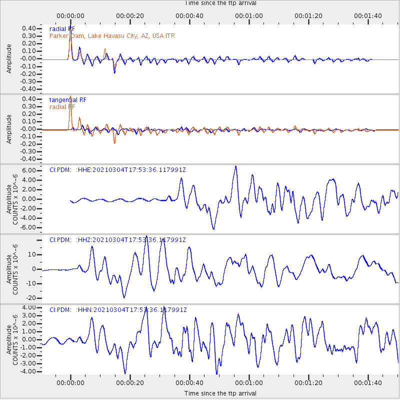
Signal To Noise
| Channel | StoN | STA | LTA |
| CI:PDM: :HHZ:20210304T17:53:36.117991Z | 4.5131717 | 1.3669986E-6 | 3.028909E-7 |
| CI:PDM: :HHN:20210304T17:53:36.117991Z | 0.7170709 | 2.1853555E-7 | 3.0476141E-7 |
| CI:PDM: :HHE:20210304T17:53:36.117991Z | 1.2421274 | 3.2081132E-7 | 2.5827572E-7 |
| Arrivals |
| Ps | 3.0 SECOND |
| PpPs | 12 SECOND |
| PsPs/PpSs | 15 SECOND |


