You are here: Home > Network List > G - GEOSCOPE Stations List
> Station DRV Dumont d'Urville, Terre Adelie (Antartica) > Earthquake Result Viewer
DRV Dumont d'Urville, Terre Adelie (Antartica) - Earthquake Result Viewer
| Earthquake location: |
Kermadec Islands, New Zealand |
| Earthquake latitude/longitude: |
-29.6/-177.8 |
| Earthquake time(UTC): |
2021/03/04 (063) 17:41:25 GMT |
| Earthquake Depth: |
56 km |
| Earthquake Magnitude: |
7.4 mww |
| Earthquake Catalog/Contributor: |
NEIC PDE/us |
|
| Network: |
G GEOSCOPE |
| Station: |
DRV Dumont d'Urville, Terre Adelie (Antartica) |
| Lat/Lon: |
66.67 S/140.01 E |
| Elevation: |
40 m |
|
| Distance: |
44.9 deg |
| Az: |
202.246 deg |
| Baz: |
55.852 deg |
| Ray Param: |
0.07146789 |
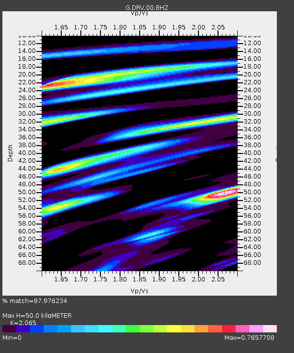
| Estimated Moho Depth: |
50.0 km |
| Estimated Crust Vp/Vs: |
2.07 |
| Assumed Crust Vp: |
6.39 km/s |
| Estimated Crust Vs: |
3.094 km/s |
| Estimated Crust Poisson's Ratio: |
0.35 |
|
| Radial Match: |
97.976234 % |
| Radial Bump: |
284 |
| Transverse Match: |
92.05877 % |
| Transverse Bump: |
400 |
| SOD ConfigId: |
23341671 |
| Insert Time: |
2021-03-18 18:53:12.934 +0000 |
| GWidth: |
2.5 |
| Max Bumps: |
400 |
| Tol: |
0.001 |
|
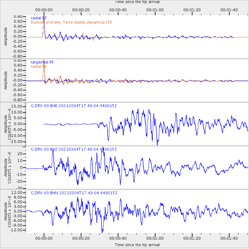
Signal To Noise
| Channel | StoN | STA | LTA |
| G:DRV:00:BHZ:20210304T17:49:04.449015Z | 19.548084 | 7.004643E-6 | 3.5832886E-7 |
| G:DRV:00:BHN:20210304T17:49:04.449015Z | 9.1105 | 2.599171E-6 | 2.85294E-7 |
| G:DRV:00:BHE:20210304T17:49:04.449015Z | 10.479697 | 3.740004E-6 | 3.5688092E-7 |
| Arrivals |
| Ps | 8.8 SECOND |
| PpPs | 23 SECOND |
| PsPs/PpSs | 32 SECOND |


