You are here: Home > Network List > GE - GEOFON Stations List
> Station MORC GEOFON Station Moravsky Beroun, Czech Republic > Earthquake Result Viewer
MORC GEOFON Station Moravsky Beroun, Czech Republic - Earthquake Result Viewer
| Earthquake location: |
Kuril Islands |
| Earthquake latitude/longitude: |
44.7/149.4 |
| Earthquake time(UTC): |
1994/05/18 (138) 03:54:02 GMT |
| Earthquake Depth: |
46 km |
| Earthquake Magnitude: |
5.8 MB, 5.8 MS, 5.5 UNKNOWN, 6.2 MW |
| Earthquake Catalog/Contributor: |
WHDF/NEIC |
|
| Network: |
GE GEOFON |
| Station: |
MORC GEOFON Station Moravsky Beroun, Czech Republic |
| Lat/Lon: |
49.78 N/17.54 E |
| Elevation: |
740 m |
|
| Distance: |
77.0 deg |
| Az: |
330.321 deg |
| Baz: |
33.014 deg |
| Ray Param: |
0.05052552 |
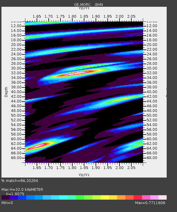
| Estimated Moho Depth: |
32.0 km |
| Estimated Crust Vp/Vs: |
1.81 |
| Assumed Crust Vp: |
6.276 km/s |
| Estimated Crust Vs: |
3.472 km/s |
| Estimated Crust Poisson's Ratio: |
0.28 |
|
| Radial Match: |
96.20284 % |
| Radial Bump: |
368 |
| Transverse Match: |
80.9873 % |
| Transverse Bump: |
400 |
| SOD ConfigId: |
16938 |
| Insert Time: |
2010-03-09 05:53:57.000 +0000 |
| GWidth: |
2.5 |
| Max Bumps: |
400 |
| Tol: |
0.001 |
|

Signal To Noise
| Channel | StoN | STA | LTA |
| GE:MORC: :BHN:19940518T04:05:19.991003Z | 9.063481 | 6.882209E-7 | 7.593339E-8 |
| GE:MORC: :BHE:19940518T04:05:19.991003Z | 6.5746503 | 5.9124324E-7 | 8.992771E-8 |
| GE:MORC: :BHZ:19940518T04:05:19.991003Z | 48.52781 | 1.8796628E-6 | 3.8733727E-8 |
| Arrivals |
| Ps | 4.2 SECOND |
| PpPs | 14 SECOND |
| PsPs/PpSs | 18 SECOND |


