You are here: Home > Network List > TA - USArray Transportable Network (new EarthScope stations) Stations List
> Station G21K Allakaket, AK, USA > Earthquake Result Viewer
G21K Allakaket, AK, USA - Earthquake Result Viewer
| Earthquake location: |
Kermadec Islands, New Zealand |
| Earthquake latitude/longitude: |
-29.6/-177.8 |
| Earthquake time(UTC): |
2021/03/04 (063) 17:41:25 GMT |
| Earthquake Depth: |
56 km |
| Earthquake Magnitude: |
7.4 mww |
| Earthquake Catalog/Contributor: |
NEIC PDE/us |
|
| Network: |
TA USArray Transportable Network (new EarthScope stations) |
| Station: |
G21K Allakaket, AK, USA |
| Lat/Lon: |
66.52 N/153.51 W |
| Elevation: |
446 m |
|
| Distance: |
97.6 deg |
| Az: |
9.591 deg |
| Baz: |
201.226 deg |
| Ray Param: |
0.040125255 |
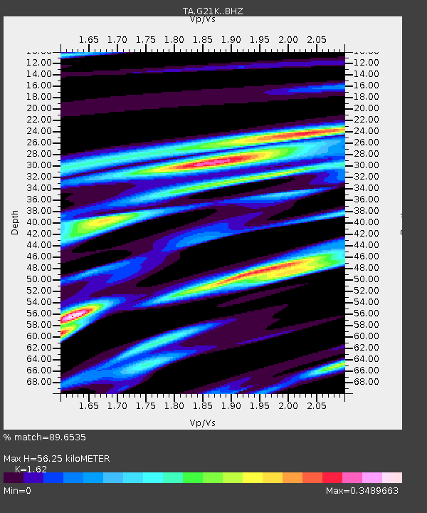
| Estimated Moho Depth: |
56.25 km |
| Estimated Crust Vp/Vs: |
1.62 |
| Assumed Crust Vp: |
6.455 km/s |
| Estimated Crust Vs: |
3.985 km/s |
| Estimated Crust Poisson's Ratio: |
0.19 |
|
| Radial Match: |
89.6535 % |
| Radial Bump: |
400 |
| Transverse Match: |
53.0985 % |
| Transverse Bump: |
400 |
| SOD ConfigId: |
23341671 |
| Insert Time: |
2021-03-18 18:58:00.078 +0000 |
| GWidth: |
2.5 |
| Max Bumps: |
400 |
| Tol: |
0.001 |
|
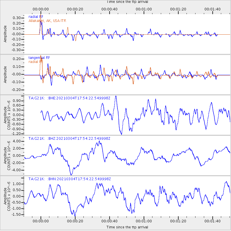
Signal To Noise
| Channel | StoN | STA | LTA |
| TA:G21K: :BHZ:20210304T17:54:22.549998Z | 3.0045526 | 7.747556E-7 | 2.5786056E-7 |
| TA:G21K: :BHN:20210304T17:54:22.549998Z | 0.94666463 | 2.456584E-7 | 2.5949888E-7 |
| TA:G21K: :BHE:20210304T17:54:22.549998Z | 0.7395067 | 1.4488582E-7 | 1.9592225E-7 |
| Arrivals |
| Ps | 5.5 SECOND |
| PpPs | 22 SECOND |
| PsPs/PpSs | 28 SECOND |


