You are here: Home > Network List > UO - University of Oregon Regional Network Stations List
> Station GROV Forest Grove, OR, USA > Earthquake Result Viewer
GROV Forest Grove, OR, USA - Earthquake Result Viewer
| Earthquake location: |
Kermadec Islands, New Zealand |
| Earthquake latitude/longitude: |
-29.6/-177.8 |
| Earthquake time(UTC): |
2021/03/04 (063) 17:41:25 GMT |
| Earthquake Depth: |
56 km |
| Earthquake Magnitude: |
7.4 mww |
| Earthquake Catalog/Contributor: |
NEIC PDE/us |
|
| Network: |
UO University of Oregon Regional Network |
| Station: |
GROV Forest Grove, OR, USA |
| Lat/Lon: |
45.54 N/123.16 W |
| Elevation: |
99 m |
|
| Distance: |
89.8 deg |
| Az: |
34.995 deg |
| Baz: |
225.281 deg |
| Ray Param: |
0.041729264 |
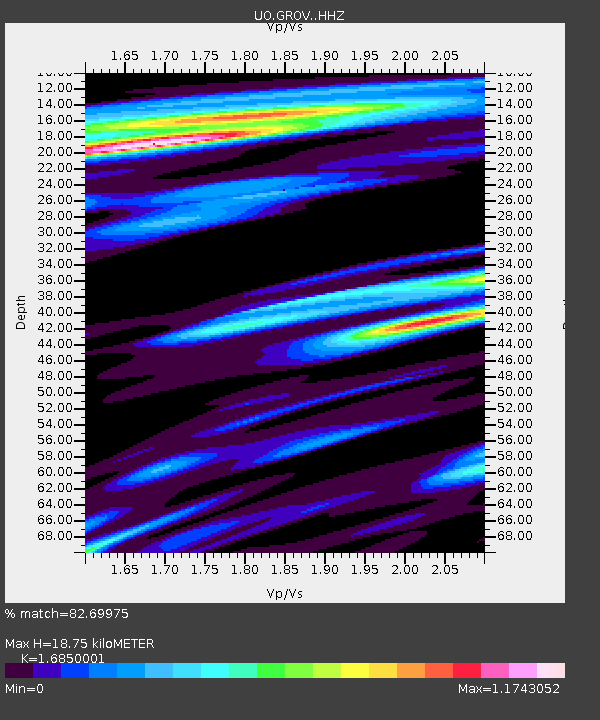
| Estimated Moho Depth: |
18.75 km |
| Estimated Crust Vp/Vs: |
1.69 |
| Assumed Crust Vp: |
6.566 km/s |
| Estimated Crust Vs: |
3.897 km/s |
| Estimated Crust Poisson's Ratio: |
0.23 |
|
| Radial Match: |
82.69975 % |
| Radial Bump: |
400 |
| Transverse Match: |
73.93171 % |
| Transverse Bump: |
400 |
| SOD ConfigId: |
23341671 |
| Insert Time: |
2021-03-18 18:59:59.946 +0000 |
| GWidth: |
2.5 |
| Max Bumps: |
400 |
| Tol: |
0.001 |
|

Signal To Noise
| Channel | StoN | STA | LTA |
| UO:GROV: :HHZ:20210304T17:53:46.770029Z | 2.3115692 | 2.2616975E-6 | 9.784252E-7 |
| UO:GROV: :HHN:20210304T17:53:46.770029Z | 0.6420535 | 1.1159071E-6 | 1.7380283E-6 |
| UO:GROV: :HHE:20210304T17:53:46.770029Z | 1.1401894 | 2.007095E-6 | 1.7603172E-6 |
| Arrivals |
| Ps | 2.0 SECOND |
| PpPs | 7.5 SECOND |
| PsPs/PpSs | 9.5 SECOND |


