You are here: Home > Network List > AK - Alaska Regional Network Stations List
> Station BAGL Bagley Icefield, AK, USA > Earthquake Result Viewer
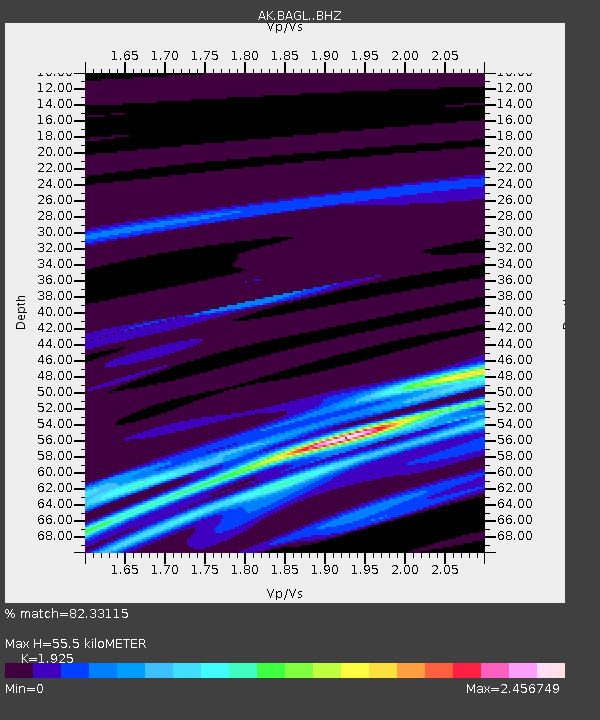
BAGL Bagley Icefield, AK, USA - Earthquake Result Viewer
| Earthquake location: |
Kermadec Islands Region |
| Earthquake latitude/longitude: |
-29.8/-175.7 |
| Earthquake time(UTC): |
2021/03/04 (063) 17:59:00 GMT |
| Earthquake Depth: |
10 km |
| Earthquake Magnitude: |
5.5 mb |
| Earthquake Catalog/Contributor: |
NEIC PDE/us |
|
| Network: |
AK Alaska Regional Network |
| Station: |
BAGL Bagley Icefield, AK, USA |
| Lat/Lon: |
60.49 N/142.09 W |
| Elevation: |
1470 m |
|
| Distance: |
94.1 deg |
| Az: |
15.957 deg |
| Baz: |
208.859 deg |
| Ray Param: |
0.041124884 |
| Estimated Moho Depth: |
55.5 km |
| Estimated Crust Vp/Vs: |
1.92 |
| Assumed Crust Vp: |
6.566 km/s |
| Estimated Crust Vs: |
3.411 km/s |
| Estimated Crust Poisson's Ratio: |
0.32 |
|
| Radial Match: |
82.33115 % |
| Radial Bump: |
197 |
| Transverse Match: |
43.300705 % |
| Transverse Bump: |
400 |
| SOD ConfigId: |
23341671 |
| Insert Time: |
2021-03-18 19:02:19.032 +0000 |
| GWidth: |
2.5 |
| Max Bumps: |
400 |
| Tol: |
0.001 |
|

Signal To Noise
| Channel | StoN | STA | LTA |
| AK:BAGL: :BHZ:20210304T18:11:47.288014Z | 0.5495066 | 1.7073431E-6 | 3.1070476E-6 |
| AK:BAGL: :BHN:20210304T18:11:47.288014Z | 2.425855 | 7.788739E-6 | 3.2107193E-6 |
| AK:BAGL: :BHE:20210304T18:11:47.288014Z | 0.6873972 | 2.2325821E-6 | 3.2478779E-6 |
| Arrivals |
| Ps | 8.0 SECOND |
| PpPs | 24 SECOND |
| PsPs/PpSs | 32 SECOND |


