You are here: Home > Network List > GE - GEOFON Stations List
> Station MORC GEOFON Station Moravsky Beroun, Czech Republic > Earthquake Result Viewer
MORC GEOFON Station Moravsky Beroun, Czech Republic - Earthquake Result Viewer
| Earthquake location: |
Samar, Philippines |
| Earthquake latitude/longitude: |
12.0/125.7 |
| Earthquake time(UTC): |
1995/04/21 (111) 00:09:56 GMT |
| Earthquake Depth: |
33 km |
| Earthquake Magnitude: |
6.1 MB, 6.9 MS, 6.9 UNKNOWN, 6.8 MW |
| Earthquake Catalog/Contributor: |
WHDF/NEIC |
|
| Network: |
GE GEOFON |
| Station: |
MORC GEOFON Station Moravsky Beroun, Czech Republic |
| Lat/Lon: |
49.78 N/17.54 E |
| Elevation: |
740 m |
|
| Distance: |
92.3 deg |
| Az: |
321.937 deg |
| Baz: |
68.509 deg |
| Ray Param: |
0.041468497 |
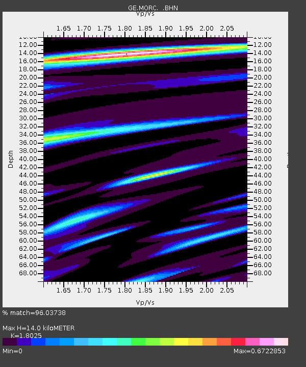
| Estimated Moho Depth: |
14.0 km |
| Estimated Crust Vp/Vs: |
1.80 |
| Assumed Crust Vp: |
6.276 km/s |
| Estimated Crust Vs: |
3.482 km/s |
| Estimated Crust Poisson's Ratio: |
0.28 |
|
| Radial Match: |
96.03738 % |
| Radial Bump: |
319 |
| Transverse Match: |
73.39207 % |
| Transverse Bump: |
400 |
| SOD ConfigId: |
6273 |
| Insert Time: |
2010-03-09 05:54:34.348 +0000 |
| GWidth: |
2.5 |
| Max Bumps: |
400 |
| Tol: |
0.001 |
|

Signal To Noise
| Channel | StoN | STA | LTA |
| GE:MORC: :BHN:19950421T00:22:31.770007Z | 2.7704394 | 3.3525257E-7 | 1.2101061E-7 |
| GE:MORC: :BHE:19950421T00:22:31.770007Z | 3.2715979 | 3.6984372E-7 | 1.13046816E-7 |
| GE:MORC: :BHZ:19950421T00:22:31.770007Z | 17.798384 | 1.4464609E-6 | 8.126923E-8 |
| Arrivals |
| Ps | 1.8 SECOND |
| PpPs | 6.1 SECOND |
| PsPs/PpSs | 8.0 SECOND |


