You are here: Home > Network List > GE - GEOFON Stations List
> Station MORC GEOFON Station Moravsky Beroun, Czech Republic > Earthquake Result Viewer
MORC GEOFON Station Moravsky Beroun, Czech Republic - Earthquake Result Viewer
| Earthquake location: |
Samar, Philippines |
| Earthquake latitude/longitude: |
12.4/125.4 |
| Earthquake time(UTC): |
1995/04/23 (113) 05:08:03 GMT |
| Earthquake Depth: |
33 km |
| Earthquake Magnitude: |
6.0 MB, 6.6 MS, 6.7 UNKNOWN, 6.7 MW |
| Earthquake Catalog/Contributor: |
WHDF/NEIC |
|
| Network: |
GE GEOFON |
| Station: |
MORC GEOFON Station Moravsky Beroun, Czech Republic |
| Lat/Lon: |
49.78 N/17.54 E |
| Elevation: |
740 m |
|
| Distance: |
91.8 deg |
| Az: |
321.866 deg |
| Baz: |
68.535 deg |
| Ray Param: |
0.041543934 |
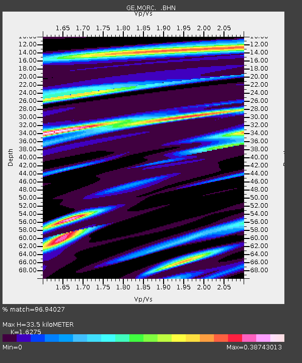
| Estimated Moho Depth: |
33.5 km |
| Estimated Crust Vp/Vs: |
1.63 |
| Assumed Crust Vp: |
6.276 km/s |
| Estimated Crust Vs: |
3.856 km/s |
| Estimated Crust Poisson's Ratio: |
0.20 |
|
| Radial Match: |
96.94027 % |
| Radial Bump: |
312 |
| Transverse Match: |
74.30576 % |
| Transverse Bump: |
400 |
| SOD ConfigId: |
6273 |
| Insert Time: |
2010-03-09 05:54:36.762 +0000 |
| GWidth: |
2.5 |
| Max Bumps: |
400 |
| Tol: |
0.001 |
|

Signal To Noise
| Channel | StoN | STA | LTA |
| GE:MORC: :BHN:19950423T05:20:36.481006Z | 1.2025057 | 1.9047337E-7 | 1.5839706E-7 |
| GE:MORC: :BHE:19950423T05:20:36.481006Z | 2.43231 | 3.730705E-7 | 1.5338112E-7 |
| GE:MORC: :BHZ:19950423T05:20:36.481006Z | 5.97715 | 1.0208003E-6 | 1.7078376E-7 |
| Arrivals |
| Ps | 3.4 SECOND |
| PpPs | 14 SECOND |
| PsPs/PpSs | 17 SECOND |


