You are here: Home > Network List > GE - GEOFON Stations List
> Station MORC GEOFON Station Moravsky Beroun, Czech Republic > Earthquake Result Viewer
MORC GEOFON Station Moravsky Beroun, Czech Republic - Earthquake Result Viewer
| Earthquake location: |
Eastern Sea Of Japan |
| Earthquake latitude/longitude: |
43.2/138.9 |
| Earthquake time(UTC): |
1996/12/22 (357) 14:53:27 GMT |
| Earthquake Depth: |
227 km |
| Earthquake Magnitude: |
6.0 MB, 6.5 UNKNOWN, 6.5 MW |
| Earthquake Catalog/Contributor: |
WHDF/NEIC |
|
| Network: |
GE GEOFON |
| Station: |
MORC GEOFON Station Moravsky Beroun, Czech Republic |
| Lat/Lon: |
49.78 N/17.54 E |
| Elevation: |
740 m |
|
| Distance: |
74.2 deg |
| Az: |
324.881 deg |
| Baz: |
40.453 deg |
| Ray Param: |
0.051892128 |
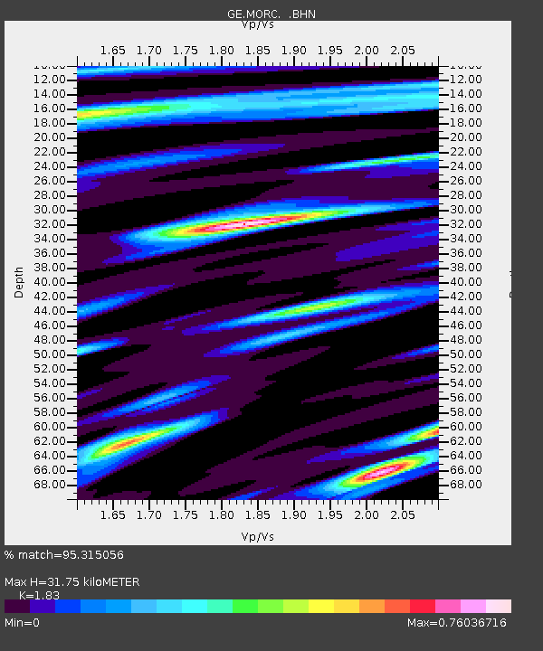
| Estimated Moho Depth: |
31.75 km |
| Estimated Crust Vp/Vs: |
1.83 |
| Assumed Crust Vp: |
6.276 km/s |
| Estimated Crust Vs: |
3.429 km/s |
| Estimated Crust Poisson's Ratio: |
0.29 |
|
| Radial Match: |
95.315056 % |
| Radial Bump: |
297 |
| Transverse Match: |
86.45651 % |
| Transverse Bump: |
400 |
| SOD ConfigId: |
6273 |
| Insert Time: |
2010-03-09 05:54:48.112 +0000 |
| GWidth: |
2.5 |
| Max Bumps: |
400 |
| Tol: |
0.001 |
|

Signal To Noise
| Channel | StoN | STA | LTA |
| GE:MORC: :BHN:19961222T15:04:08.227014Z | 7.4418397 | 9.928359E-7 | 1.334127E-7 |
| GE:MORC: :BHE:19961222T15:04:08.227014Z | 16.814968 | 1.1233375E-6 | 6.680581E-8 |
| GE:MORC: :BHZ:19961222T15:04:08.227014Z | 30.4399 | 3.415643E-6 | 1.12209406E-7 |
| Arrivals |
| Ps | 4.3 SECOND |
| PpPs | 14 SECOND |
| PsPs/PpSs | 18 SECOND |


