You are here: Home > Network List > GM - US Geological Survey Networks Stations List
> Station IWM01 Jericho 2M Well Monitoring Station > Earthquake Result Viewer
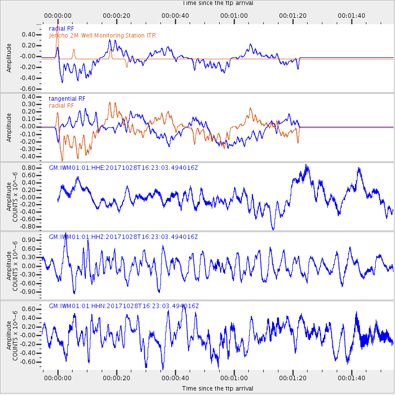
IWM01 Jericho 2M Well Monitoring Station - Earthquake Result Viewer
*The percent match for this event was below the threshold and hence no stack was calculated.
| Earthquake location: |
North Of Franz Josef Land |
| Earthquake latitude/longitude: |
86.9/54.5 |
| Earthquake time(UTC): |
2017/10/28 (301) 16:13:54 GMT |
| Earthquake Depth: |
10 km |
| Earthquake Magnitude: |
5.8 Mww |
| Earthquake Catalog/Contributor: |
NEIC PDE/us |
|
| Network: |
GM US Geological Survey Networks |
| Station: |
IWM01 Jericho 2M Well Monitoring Station |
| Lat/Lon: |
36.73 N/96.53 W |
| Elevation: |
328 m |
|
| Distance: |
56.2 deg |
| Az: |
332.078 deg |
| Baz: |
1.824 deg |
| Ray Param: |
$rayparam |
*The percent match for this event was below the threshold and hence was not used in the summary stack. |
|
| Radial Match: |
68.01282 % |
| Radial Bump: |
400 |
| Transverse Match: |
22.507599 % |
| Transverse Bump: |
400 |
| SOD ConfigId: |
2364251 |
| Insert Time: |
2017-11-11 16:15:27.646 +0000 |
| GWidth: |
2.5 |
| Max Bumps: |
400 |
| Tol: |
0.001 |
|
Signal To Noise
| Channel | StoN | STA | LTA |
| GM:IWM01:01:HHZ:20171028T16:23:03.494016Z | 3.2953157 | 4.7960515E-7 | 1.4554149E-7 |
| GM:IWM01:01:HHN:20171028T16:23:03.494016Z | 1.0566411 | 2.4854882E-7 | 2.3522541E-7 |
| GM:IWM01:01:HHE:20171028T16:23:03.494016Z | 0.37314922 | 8.5268525E-8 | 2.2851052E-7 |
| Arrivals |
| Ps | |
| PpPs | |
| PsPs/PpSs | |


