You are here: Home > Network List > TA - USArray Transportable Network (new EarthScope stations) Stations List
> Station I17K Unalakleet, AK, USA > Earthquake Result Viewer
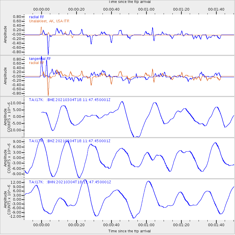
I17K Unalakleet, AK, USA - Earthquake Result Viewer
*The percent match for this event was below the threshold and hence no stack was calculated.
| Earthquake location: |
Kermadec Islands Region |
| Earthquake latitude/longitude: |
-29.8/-175.7 |
| Earthquake time(UTC): |
2021/03/04 (063) 17:59:00 GMT |
| Earthquake Depth: |
10 km |
| Earthquake Magnitude: |
5.5 mb |
| Earthquake Catalog/Contributor: |
NEIC PDE/us |
|
| Network: |
TA USArray Transportable Network (new EarthScope stations) |
| Station: |
I17K Unalakleet, AK, USA |
| Lat/Lon: |
63.89 N/160.70 W |
| Elevation: |
105 m |
|
| Distance: |
94.1 deg |
| Az: |
6.607 deg |
| Baz: |
193.061 deg |
| Ray Param: |
$rayparam |
*The percent match for this event was below the threshold and hence was not used in the summary stack. |
|
| Radial Match: |
69.84049 % |
| Radial Bump: |
400 |
| Transverse Match: |
52.812008 % |
| Transverse Bump: |
400 |
| SOD ConfigId: |
23341671 |
| Insert Time: |
2021-03-18 19:13:58.394 +0000 |
| GWidth: |
2.5 |
| Max Bumps: |
400 |
| Tol: |
0.001 |
|
Signal To Noise
| Channel | StoN | STA | LTA |
| TA:I17K: :BHZ:20210304T18:11:47.450001Z | 2.02666 | 8.274216E-6 | 4.082686E-6 |
| TA:I17K: :BHN:20210304T18:11:47.450001Z | 1.6501191 | 7.707049E-6 | 4.6706014E-6 |
| TA:I17K: :BHE:20210304T18:11:47.450001Z | 0.30148175 | 1.593198E-6 | 5.284559E-6 |
| Arrivals |
| Ps | |
| PpPs | |
| PsPs/PpSs | |


