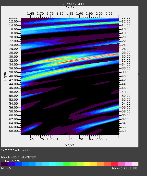
MORC GEOFON Station Moravsky Beroun, Czech Republic - Earthquake Result Viewer

Earthquake location: Northern Mid-Atlantic Ridge
Earthquake latitude/longitude: 10.8/-42.3
Earthquake time(UTC): 1996/06/02 (154) 02:52:09 GMT
Earthquake Depth: 10 km
Earthquake Magnitude: 6.1 MB, 6.9 MS, 7.0 UNKNOWN, 6.8 MW
Earthquake Catalog/Contributor: WHDF/NEIC
Network: GE GEOFON
Station: MORC GEOFON Station Moravsky Beroun, Czech Republic
Lat/Lon: 49.78 N/17.54 E
Elevation: 740 m
Distance: 62.5 deg
Az: 39.184 deg
Baz: 253.243 deg
Ray Param: 0.0602022
Estimated Moho Depth: 30.0 km
Estimated Crust Vp/Vs: 1.98
Assumed Crust Vp: 6.276 km/s
Estimated Crust Vs: 3.174 km/s
Estimated Crust Poisson's Ratio: 0.33
Radial Match: 97.65809 %
Radial Bump: 364
Transverse Match: 92.63212 %
Transverse Bump: 400
SOD ConfigId: 6273
Insert Time: 2010-03-09 05:55:02.421 +0000
GWidth: 2.5
Max Bumps: 400
Tol: 0.001

Signal To Noise

ChannelStoNSTALTA
GE:MORC: :BHN:19960602T03:02:01.778015Z1.06511581.3489021E-71.2664371E-7
GE:MORC: :BHE:19960602T03:02:01.778015Z3.20838023.6701928E-71.1439395E-7
GE:MORC: :BHZ:19960602T03:02:01.778015Z5.87086968.839484E-71.5056517E-7
Arrivals
Ps4.9 SECOND
PpPs14 SECOND
PsPs/PpSs19 SECOND