You are here: Home > Network List > UU - University of Utah Regional Network Stations List
> Station CCUT Cedar City, UT, USA > Earthquake Result Viewer
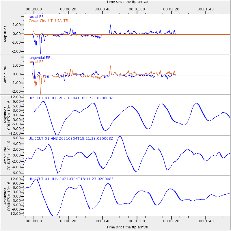
CCUT Cedar City, UT, USA - Earthquake Result Viewer
*The percent match for this event was below the threshold and hence no stack was calculated.
| Earthquake location: |
Kermadec Islands Region |
| Earthquake latitude/longitude: |
-29.8/-175.7 |
| Earthquake time(UTC): |
2021/03/04 (063) 17:59:00 GMT |
| Earthquake Depth: |
10 km |
| Earthquake Magnitude: |
5.5 mb |
| Earthquake Catalog/Contributor: |
NEIC PDE/us |
|
| Network: |
UU University of Utah Regional Network |
| Station: |
CCUT Cedar City, UT, USA |
| Lat/Lon: |
37.55 N/113.36 W |
| Elevation: |
2127 m |
|
| Distance: |
88.8 deg |
| Az: |
44.769 deg |
| Baz: |
230.369 deg |
| Ray Param: |
$rayparam |
*The percent match for this event was below the threshold and hence was not used in the summary stack. |
|
| Radial Match: |
81.41106 % |
| Radial Bump: |
354 |
| Transverse Match: |
68.51443 % |
| Transverse Bump: |
400 |
| SOD ConfigId: |
23341671 |
| Insert Time: |
2021-03-18 19:16:35.719 +0000 |
| GWidth: |
2.5 |
| Max Bumps: |
400 |
| Tol: |
0.001 |
|
Signal To Noise
| Channel | StoN | STA | LTA |
| UU:CCUT:01:HHZ:20210304T18:11:23.020008Z | 0.79425037 | 2.1388487E-6 | 2.692915E-6 |
| UU:CCUT:01:HHN:20210304T18:11:23.020008Z | 2.2723737 | 1.1624027E-5 | 5.115368E-6 |
| UU:CCUT:01:HHE:20210304T18:11:23.020008Z | 1.0321814 | 6.922583E-6 | 6.706751E-6 |
| Arrivals |
| Ps | |
| PpPs | |
| PsPs/PpSs | |


