You are here: Home > Network List > GE - GEOFON Stations List
> Station MORC GEOFON Station Moravsky Beroun, Czech Republic > Earthquake Result Viewer
MORC GEOFON Station Moravsky Beroun, Czech Republic - Earthquake Result Viewer
| Earthquake location: |
Arabian Sea |
| Earthquake latitude/longitude: |
12.4/58.1 |
| Earthquake time(UTC): |
1996/10/01 (275) 15:50:23 GMT |
| Earthquake Depth: |
10 km |
| Earthquake Magnitude: |
5.8 MB, 5.9 MS, 6.4 UNKNOWN, 6.3 MW |
| Earthquake Catalog/Contributor: |
WHDF/NEIC |
|
| Network: |
GE GEOFON |
| Station: |
MORC GEOFON Station Moravsky Beroun, Czech Republic |
| Lat/Lon: |
49.78 N/17.54 E |
| Elevation: |
740 m |
|
| Distance: |
49.9 deg |
| Az: |
326.579 deg |
| Baz: |
123.91 deg |
| Ray Param: |
0.068414085 |
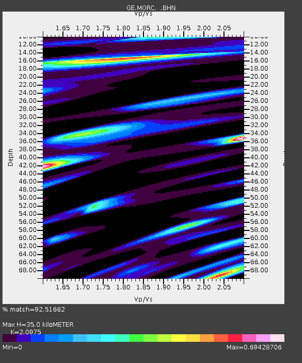
| Estimated Moho Depth: |
35.0 km |
| Estimated Crust Vp/Vs: |
2.10 |
| Assumed Crust Vp: |
6.276 km/s |
| Estimated Crust Vs: |
2.992 km/s |
| Estimated Crust Poisson's Ratio: |
0.35 |
|
| Radial Match: |
92.51662 % |
| Radial Bump: |
400 |
| Transverse Match: |
81.2626 % |
| Transverse Bump: |
400 |
| SOD ConfigId: |
6273 |
| Insert Time: |
2010-03-09 05:55:24.326 +0000 |
| GWidth: |
2.5 |
| Max Bumps: |
400 |
| Tol: |
0.001 |
|

Signal To Noise
| Channel | StoN | STA | LTA |
| GE:MORC: :BHN:19961001T15:58:46.140009Z | 1.791286 | 9.95787E-8 | 5.559062E-8 |
| GE:MORC: :BHE:19961001T15:58:46.140009Z | 2.5351608 | 1.9005658E-7 | 7.4968256E-8 |
| GE:MORC: :BHZ:19961001T15:58:46.140009Z | 4.1838317 | 3.5577858E-7 | 8.503655E-8 |
| Arrivals |
| Ps | 6.4 SECOND |
| PpPs | 16 SECOND |
| PsPs/PpSs | 23 SECOND |


