You are here: Home > Network List > GE - GEOFON Stations List
> Station MORC GEOFON Station Moravsky Beroun, Czech Republic > Earthquake Result Viewer
MORC GEOFON Station Moravsky Beroun, Czech Republic - Earthquake Result Viewer
| Earthquake location: |
Southern India |
| Earthquake latitude/longitude: |
23.1/80.0 |
| Earthquake time(UTC): |
1997/05/21 (141) 22:51:28 GMT |
| Earthquake Depth: |
36 km |
| Earthquake Magnitude: |
6.0 MB, 5.6 MS, 5.8 UNKNOWN, 5.6 ME |
| Earthquake Catalog/Contributor: |
WHDF/NEIC |
|
| Network: |
GE GEOFON |
| Station: |
MORC GEOFON Station Moravsky Beroun, Czech Republic |
| Lat/Lon: |
49.78 N/17.54 E |
| Elevation: |
740 m |
|
| Distance: |
55.1 deg |
| Az: |
315.465 deg |
| Baz: |
94.971 deg |
| Ray Param: |
0.06496313 |
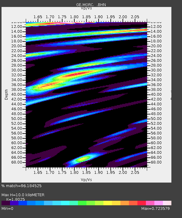
| Estimated Moho Depth: |
10.0 km |
| Estimated Crust Vp/Vs: |
1.80 |
| Assumed Crust Vp: |
6.276 km/s |
| Estimated Crust Vs: |
3.482 km/s |
| Estimated Crust Poisson's Ratio: |
0.28 |
|
| Radial Match: |
96.184525 % |
| Radial Bump: |
389 |
| Transverse Match: |
90.50662 % |
| Transverse Bump: |
400 |
| SOD ConfigId: |
6273 |
| Insert Time: |
2010-03-09 05:55:37.621 +0000 |
| GWidth: |
2.5 |
| Max Bumps: |
400 |
| Tol: |
0.001 |
|

Signal To Noise
| Channel | StoN | STA | LTA |
| GE:MORC: :BHN:19970521T23:00:26.400012Z | 1.6451946 | 5.488546E-8 | 3.3361072E-8 |
| GE:MORC: :BHE:19970521T23:00:26.400012Z | 12.677471 | 3.1049598E-7 | 2.449195E-8 |
| GE:MORC: :BHZ:19970521T23:00:26.400012Z | 8.725468 | 5.3308503E-7 | 6.10953E-8 |
| Arrivals |
| Ps | 1.3 SECOND |
| PpPs | 4.3 SECOND |
| PsPs/PpSs | 5.6 SECOND |


