You are here: Home > Network List > IU - Global Seismograph Network (GSN - IRIS/USGS) Stations List
> Station MAKZ Makanchi, Kazakhstan > Earthquake Result Viewer
MAKZ Makanchi, Kazakhstan - Earthquake Result Viewer
| Earthquake location: |
North Of Franz Josef Land |
| Earthquake latitude/longitude: |
86.9/54.5 |
| Earthquake time(UTC): |
2017/10/28 (301) 16:13:54 GMT |
| Earthquake Depth: |
10 km |
| Earthquake Magnitude: |
5.8 Mww |
| Earthquake Catalog/Contributor: |
NEIC PDE/us |
|
| Network: |
IU Global Seismograph Network (GSN - IRIS/USGS) |
| Station: |
MAKZ Makanchi, Kazakhstan |
| Lat/Lon: |
46.81 N/81.98 E |
| Elevation: |
600 m |
|
| Distance: |
40.6 deg |
| Az: |
150.869 deg |
| Baz: |
357.782 deg |
| Ray Param: |
0.07429083 |
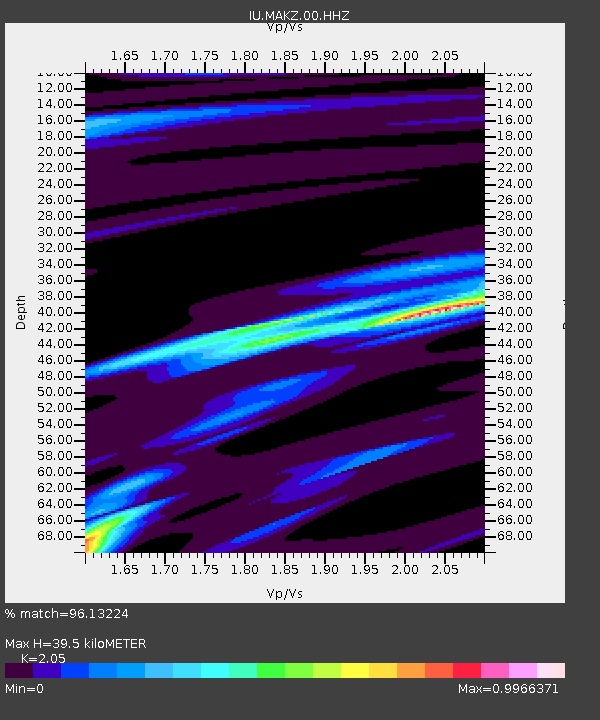
| Estimated Moho Depth: |
39.5 km |
| Estimated Crust Vp/Vs: |
2.05 |
| Assumed Crust Vp: |
6.571 km/s |
| Estimated Crust Vs: |
3.205 km/s |
| Estimated Crust Poisson's Ratio: |
0.34 |
|
| Radial Match: |
96.13224 % |
| Radial Bump: |
248 |
| Transverse Match: |
74.931 % |
| Transverse Bump: |
400 |
| SOD ConfigId: |
2364251 |
| Insert Time: |
2017-11-11 16:16:28.528 +0000 |
| GWidth: |
2.5 |
| Max Bumps: |
400 |
| Tol: |
0.001 |
|
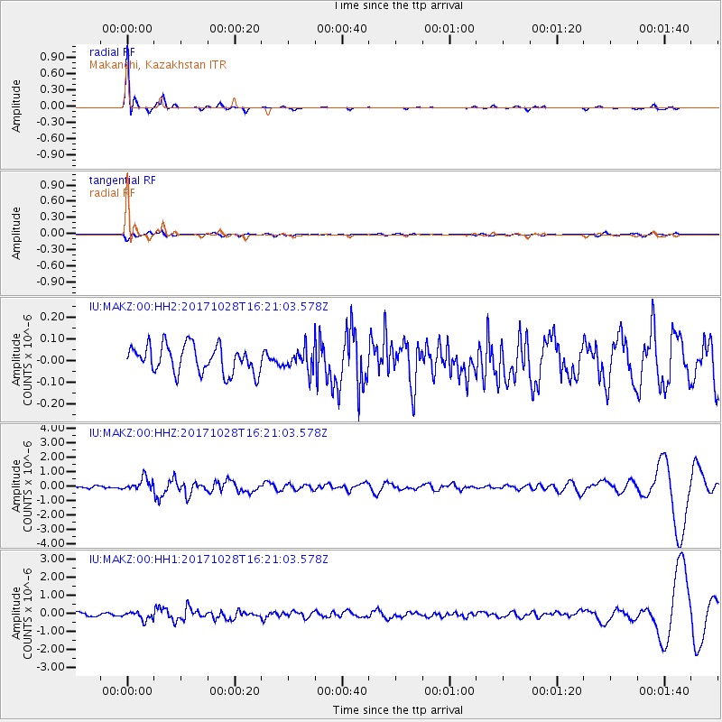
Signal To Noise
| Channel | StoN | STA | LTA |
| IU:MAKZ:00:HHZ:20171028T16:21:03.578Z | 4.1040215 | 4.371778E-7 | 1.0652424E-7 |
| IU:MAKZ:00:HH1:20171028T16:21:03.578Z | 2.3961222 | 2.2506391E-7 | 9.392839E-8 |
| IU:MAKZ:00:HH2:20171028T16:21:03.578Z | 0.76217526 | 4.8434533E-8 | 6.3547766E-8 |
| Arrivals |
| Ps | 6.7 SECOND |
| PpPs | 17 SECOND |
| PsPs/PpSs | 24 SECOND |


