You are here: Home > Network List > GE - GEOFON Stations List
> Station MORC GEOFON Station Moravsky Beroun, Czech Republic > Earthquake Result Viewer
MORC GEOFON Station Moravsky Beroun, Czech Republic - Earthquake Result Viewer
| Earthquake location: |
Off East Coast Of Kamchatka |
| Earthquake latitude/longitude: |
52.2/159.5 |
| Earthquake time(UTC): |
1998/05/27 (147) 20:41:37 GMT |
| Earthquake Depth: |
60 km |
| Earthquake Magnitude: |
5.5 MB, 6.0 UNKNOWN, 5.9 MW |
| Earthquake Catalog/Contributor: |
WHDF/NEIC |
|
| Network: |
GE GEOFON |
| Station: |
MORC GEOFON Station Moravsky Beroun, Czech Republic |
| Lat/Lon: |
49.78 N/17.54 E |
| Elevation: |
740 m |
|
| Distance: |
73.4 deg |
| Az: |
335.372 deg |
| Baz: |
23.284 deg |
| Ray Param: |
0.052930765 |
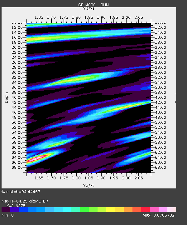
| Estimated Moho Depth: |
64.25 km |
| Estimated Crust Vp/Vs: |
1.64 |
| Assumed Crust Vp: |
6.276 km/s |
| Estimated Crust Vs: |
3.833 km/s |
| Estimated Crust Poisson's Ratio: |
0.20 |
|
| Radial Match: |
94.44467 % |
| Radial Bump: |
358 |
| Transverse Match: |
84.642494 % |
| Transverse Bump: |
400 |
| SOD ConfigId: |
4480 |
| Insert Time: |
2010-03-09 05:56:01.909 +0000 |
| GWidth: |
2.5 |
| Max Bumps: |
400 |
| Tol: |
0.001 |
|

Signal To Noise
| Channel | StoN | STA | LTA |
| GE:MORC: :BHN:19980527T20:52:32.459021Z | 27.151352 | 1.0492022E-6 | 3.8642725E-8 |
| GE:MORC: :BHE:19980527T20:52:32.459021Z | 16.07415 | 4.1538777E-7 | 2.5841976E-8 |
| GE:MORC: :BHZ:19980527T20:52:32.459021Z | 10.729106 | 2.386621E-7 | 2.2244361E-8 |
| Arrivals |
| Ps | 6.8 SECOND |
| PpPs | 26 SECOND |
| PsPs/PpSs | 33 SECOND |


