You are here: Home > Network List > IU - Global Seismograph Network (GSN - IRIS/USGS) Stations List
> Station RSSD Black Hills, South Dakota, USA > Earthquake Result Viewer
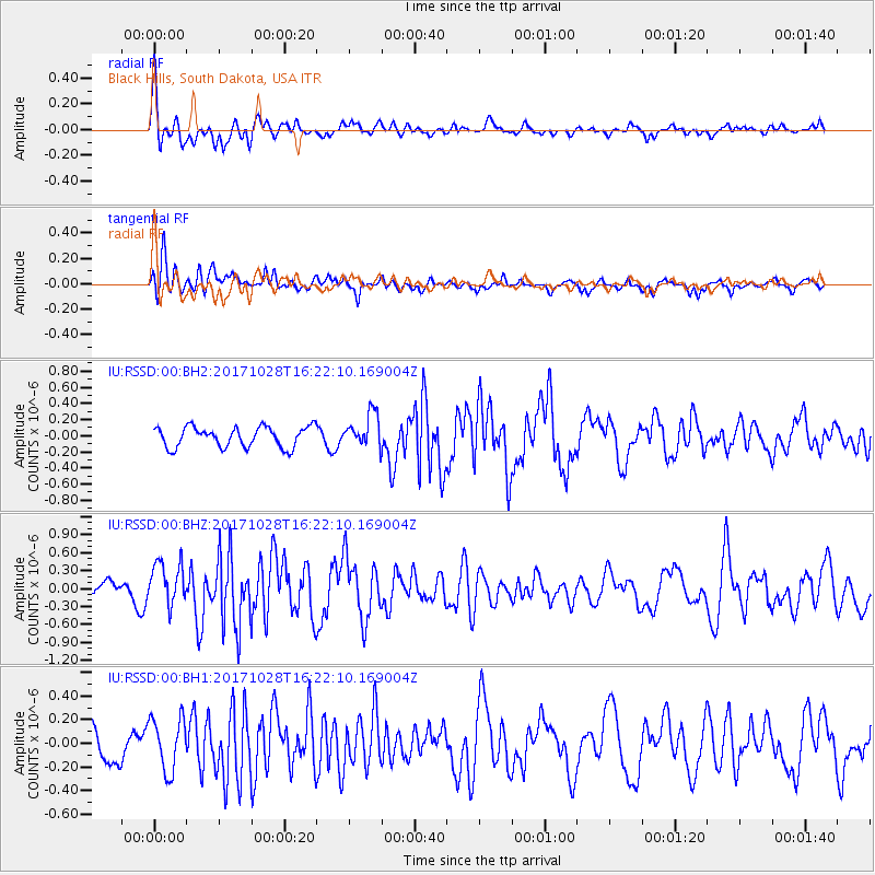
RSSD Black Hills, South Dakota, USA - Earthquake Result Viewer
*The percent match for this event was below the threshold and hence no stack was calculated.
| Earthquake location: |
North Of Franz Josef Land |
| Earthquake latitude/longitude: |
86.9/54.5 |
| Earthquake time(UTC): |
2017/10/28 (301) 16:13:54 GMT |
| Earthquake Depth: |
10 km |
| Earthquake Magnitude: |
5.8 Mww |
| Earthquake Catalog/Contributor: |
NEIC PDE/us |
|
| Network: |
IU Global Seismograph Network (GSN - IRIS/USGS) |
| Station: |
RSSD Black Hills, South Dakota, USA |
| Lat/Lon: |
44.12 N/104.04 W |
| Elevation: |
2090 m |
|
| Distance: |
49.0 deg |
| Az: |
339.556 deg |
| Baz: |
1.518 deg |
| Ray Param: |
$rayparam |
*The percent match for this event was below the threshold and hence was not used in the summary stack. |
|
| Radial Match: |
61.398315 % |
| Radial Bump: |
400 |
| Transverse Match: |
72.17199 % |
| Transverse Bump: |
400 |
| SOD ConfigId: |
2364251 |
| Insert Time: |
2017-11-11 16:16:35.830 +0000 |
| GWidth: |
2.5 |
| Max Bumps: |
400 |
| Tol: |
0.001 |
|
Signal To Noise
| Channel | StoN | STA | LTA |
| IU:RSSD:00:BHZ:20171028T16:22:10.169004Z | 2.463033 | 3.6276714E-7 | 1.4728472E-7 |
| IU:RSSD:00:BH1:20171028T16:22:10.169004Z | 1.4895175 | 2.2389635E-7 | 1.5031469E-7 |
| IU:RSSD:00:BH2:20171028T16:22:10.169004Z | 1.6573898 | 2.0825499E-7 | 1.2565239E-7 |
| Arrivals |
| Ps | |
| PpPs | |
| PsPs/PpSs | |


