You are here: Home > Network List > IU - Global Seismograph Network (GSN - IRIS/USGS) Stations List
> Station XMAS Kiritimati Island, Republic of Kiribati > Earthquake Result Viewer
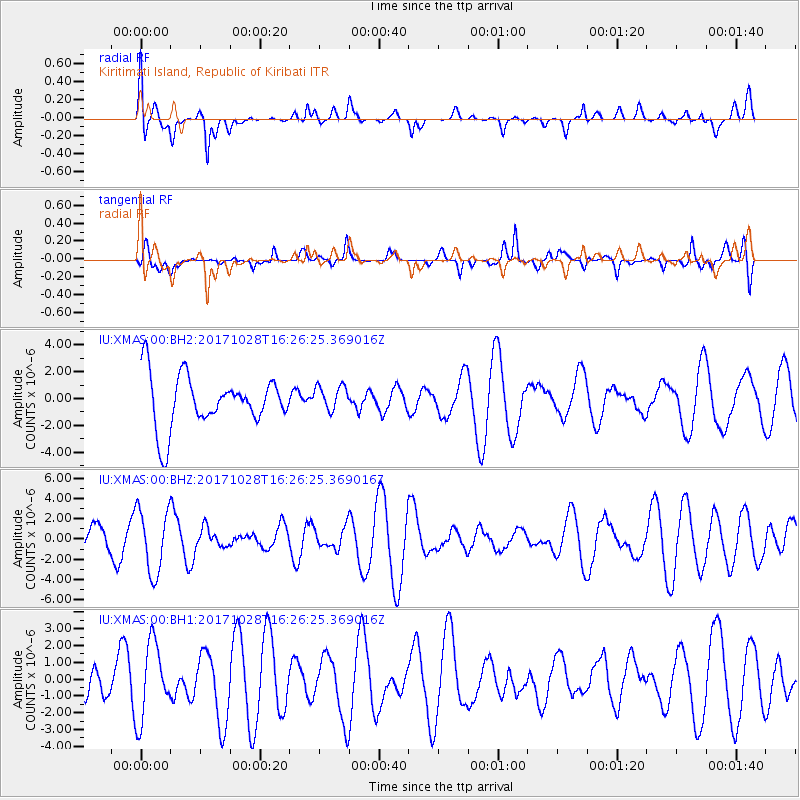
XMAS Kiritimati Island, Republic of Kiribati - Earthquake Result Viewer
*The percent match for this event was below the threshold and hence no stack was calculated.
| Earthquake location: |
North Of Franz Josef Land |
| Earthquake latitude/longitude: |
86.9/54.5 |
| Earthquake time(UTC): |
2017/10/28 (301) 16:13:54 GMT |
| Earthquake Depth: |
10 km |
| Earthquake Magnitude: |
5.8 Mww |
| Earthquake Catalog/Contributor: |
NEIC PDE/us |
|
| Network: |
IU Global Seismograph Network (GSN - IRIS/USGS) |
| Station: |
XMAS Kiritimati Island, Republic of Kiribati |
| Lat/Lon: |
2.04 N/157.45 W |
| Elevation: |
20 m |
|
| Distance: |
90.6 deg |
| Az: |
31.921 deg |
| Baz: |
358.344 deg |
| Ray Param: |
$rayparam |
*The percent match for this event was below the threshold and hence was not used in the summary stack. |
|
| Radial Match: |
55.88077 % |
| Radial Bump: |
400 |
| Transverse Match: |
55.96967 % |
| Transverse Bump: |
400 |
| SOD ConfigId: |
2364251 |
| Insert Time: |
2017-11-11 16:16:42.972 +0000 |
| GWidth: |
2.5 |
| Max Bumps: |
400 |
| Tol: |
0.001 |
|
Signal To Noise
| Channel | StoN | STA | LTA |
| IU:XMAS:00:BHZ:20171028T16:26:25.369016Z | 2.2391183 | 3.1547731E-6 | 1.4089354E-6 |
| IU:XMAS:00:BH1:20171028T16:26:25.369016Z | 1.4355091 | 2.2374047E-6 | 1.5586141E-6 |
| IU:XMAS:00:BH2:20171028T16:26:25.369016Z | 0.5021261 | 9.739937E-7 | 1.9397391E-6 |
| Arrivals |
| Ps | |
| PpPs | |
| PsPs/PpSs | |


