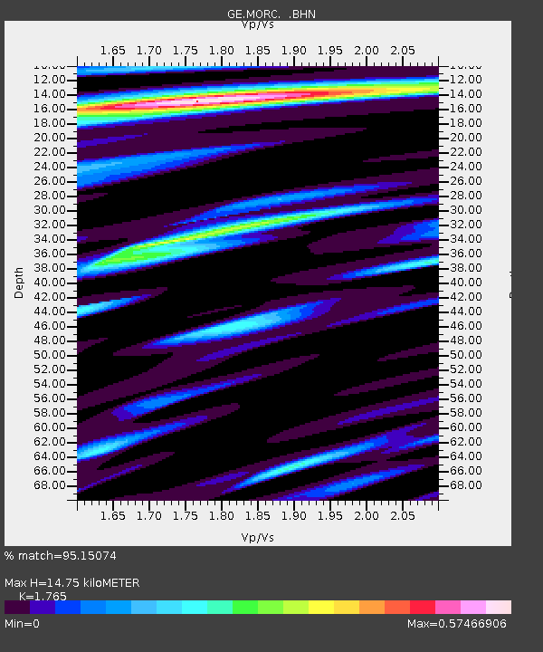
MORC GEOFON Station Moravsky Beroun, Czech Republic - Earthquake Result Viewer

Earthquake location: Northern Sumatra, Indonesia
Earthquake latitude/longitude: 2.4/96.3
Earthquake time(UTC): 2006/08/11 (223) 20:54:14 GMT
Earthquake Depth: 22 km
Earthquake Magnitude: 5.8 MB, 6.2 MS, 6.2 MW, 6.1 MW
Earthquake Catalog/Contributor: WHDF/NEIC
Network: GE GEOFON
Station: MORC GEOFON Station Moravsky Beroun, Czech Republic
Lat/Lon: 49.78 N/17.54 E
Elevation: 740 m
Distance: 80.9 deg
Az: 319.91 deg
Baz: 97.02 deg
Ray Param: 0.047913883
Estimated Moho Depth: 14.75 km
Estimated Crust Vp/Vs: 1.76
Assumed Crust Vp: 6.276 km/s
Estimated Crust Vs: 3.556 km/s
Estimated Crust Poisson's Ratio: 0.26
Radial Match: 95.15074 %
Radial Bump: 307
Transverse Match: 80.81461 %
Transverse Bump: 400
SOD ConfigId: 2665
Insert Time: 2010-03-09 05:56:54.211 +0000
GWidth: 2.5
Max Bumps: 400
Tol: 0.001

Signal To Noise

ChannelStoNSTALTA
GE:MORC: :BHN:20060811T21:05:55.614019Z1.38321884.334617E-83.1337173E-8
GE:MORC: :BHE:20060811T21:05:55.614019Z6.52161072.3142564E-73.5485964E-8
GE:MORC: :BHZ:20060811T21:05:55.614019Z22.9269776.200111E-72.7042864E-8
Arrivals
Ps1.8 SECOND
PpPs6.3 SECOND
PsPs/PpSs8.2 SECOND