You are here: Home > Network List > TA - USArray Transportable Network (new EarthScope stations) Stations List
> Station H31M Peel River, Yukon, CAN > Earthquake Result Viewer
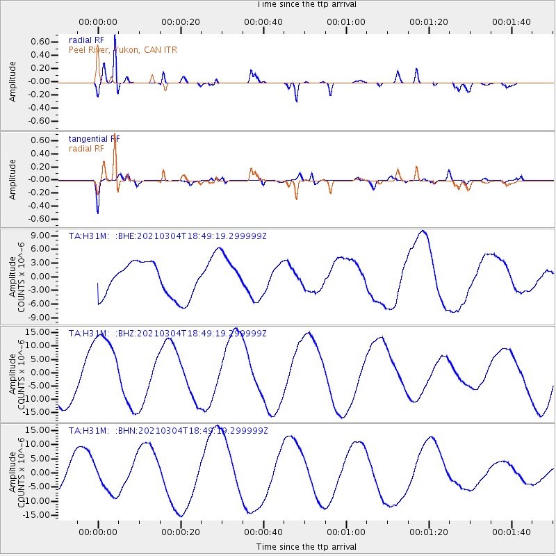
H31M Peel River, Yukon, CAN - Earthquake Result Viewer
*The percent match for this event was below the threshold and hence no stack was calculated.
| Earthquake location: |
Greece |
| Earthquake latitude/longitude: |
39.7/22.1 |
| Earthquake time(UTC): |
2021/03/04 (063) 18:38:19 GMT |
| Earthquake Depth: |
10 km |
| Earthquake Magnitude: |
5.6 mb |
| Earthquake Catalog/Contributor: |
NEIC PDE/us |
|
| Network: |
TA USArray Transportable Network (new EarthScope stations) |
| Station: |
H31M Peel River, Yukon, CAN |
| Lat/Lon: |
65.81 N/134.34 W |
| Elevation: |
642 m |
|
| Distance: |
73.2 deg |
| Az: |
350.106 deg |
| Baz: |
18.75 deg |
| Ray Param: |
$rayparam |
*The percent match for this event was below the threshold and hence was not used in the summary stack. |
|
| Radial Match: |
94.24225 % |
| Radial Bump: |
322 |
| Transverse Match: |
84.54737 % |
| Transverse Bump: |
400 |
| SOD ConfigId: |
23341671 |
| Insert Time: |
2021-03-18 19:55:19.951 +0000 |
| GWidth: |
2.5 |
| Max Bumps: |
400 |
| Tol: |
0.001 |
|
Signal To Noise
| Channel | StoN | STA | LTA |
| TA:H31M: :BHZ:20210304T18:49:19.299999Z | 1.7032806 | 1.4029496E-5 | 8.236751E-6 |
| TA:H31M: :BHN:20210304T18:49:19.299999Z | 0.76653105 | 5.426013E-6 | 7.0786605E-6 |
| TA:H31M: :BHE:20210304T18:49:19.299999Z | 1.319918 | 4.8033526E-6 | 3.6391295E-6 |
| Arrivals |
| Ps | |
| PpPs | |
| PsPs/PpSs | |


