You are here: Home > Network List > AV - Alaska Volcano Observatory Stations List
> Station KIKV Kanaga Volcano, Kanaga Volcano, Alaska > Earthquake Result Viewer
KIKV Kanaga Volcano, Kanaga Volcano, Alaska - Earthquake Result Viewer
| Earthquake location: |
Kermadec Islands, New Zealand |
| Earthquake latitude/longitude: |
-29.7/-177.3 |
| Earthquake time(UTC): |
2021/03/04 (063) 19:28:31 GMT |
| Earthquake Depth: |
19 km |
| Earthquake Magnitude: |
8.1 mww |
| Earthquake Catalog/Contributor: |
NEIC PDE/us |
|
| Network: |
AV Alaska Volcano Observatory |
| Station: |
KIKV Kanaga Volcano, Kanaga Volcano, Alaska |
| Lat/Lon: |
51.88 N/177.17 W |
| Elevation: |
411 m |
|
| Distance: |
81.3 deg |
| Az: |
0.059 deg |
| Baz: |
180.083 deg |
| Ray Param: |
0.047697682 |
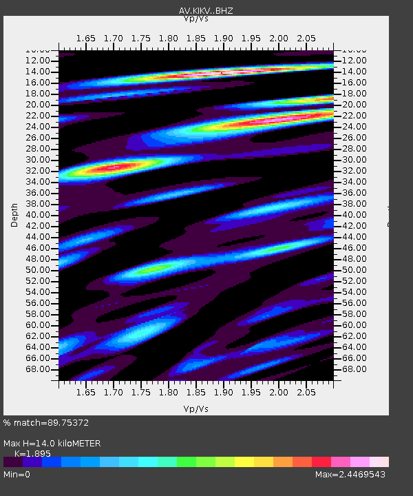
| Estimated Moho Depth: |
14.0 km |
| Estimated Crust Vp/Vs: |
1.89 |
| Assumed Crust Vp: |
5.88 km/s |
| Estimated Crust Vs: |
3.103 km/s |
| Estimated Crust Poisson's Ratio: |
0.31 |
|
| Radial Match: |
89.75372 % |
| Radial Bump: |
400 |
| Transverse Match: |
86.85895 % |
| Transverse Bump: |
400 |
| SOD ConfigId: |
23341671 |
| Insert Time: |
2021-03-18 20:46:37.936 +0000 |
| GWidth: |
2.5 |
| Max Bumps: |
400 |
| Tol: |
0.001 |
|

Signal To Noise
| Channel | StoN | STA | LTA |
| AV:KIKV: :BHZ:20210304T19:40:15.098979Z | 2.2240274 | 3.2935654E-6 | 1.4809013E-6 |
| AV:KIKV: :BHN:20210304T19:40:15.098979Z | 0.7705573 | 2.4267938E-6 | 3.149401E-6 |
| AV:KIKV: :BHE:20210304T19:40:15.098979Z | 1.0282701 | 3.3802075E-6 | 3.2872758E-6 |
| Arrivals |
| Ps | 2.2 SECOND |
| PpPs | 6.7 SECOND |
| PsPs/PpSs | 8.9 SECOND |


