You are here: Home > Network List > AV - Alaska Volcano Observatory Stations List
> Station KOFP Flat Point, Korovin Volcano, Alaska > Earthquake Result Viewer
KOFP Flat Point, Korovin Volcano, Alaska - Earthquake Result Viewer
| Earthquake location: |
Kermadec Islands, New Zealand |
| Earthquake latitude/longitude: |
-29.7/-177.3 |
| Earthquake time(UTC): |
2021/03/04 (063) 19:28:31 GMT |
| Earthquake Depth: |
19 km |
| Earthquake Magnitude: |
8.1 mww |
| Earthquake Catalog/Contributor: |
NEIC PDE/us |
|
| Network: |
AV Alaska Volcano Observatory |
| Station: |
KOFP Flat Point, Korovin Volcano, Alaska |
| Lat/Lon: |
52.27 N/174.10 W |
| Elevation: |
662 m |
|
| Distance: |
81.7 deg |
| Az: |
1.967 deg |
| Baz: |
182.784 deg |
| Ray Param: |
0.04738414 |
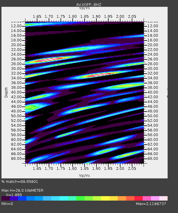
| Estimated Moho Depth: |
26.0 km |
| Estimated Crust Vp/Vs: |
1.70 |
| Assumed Crust Vp: |
5.88 km/s |
| Estimated Crust Vs: |
3.469 km/s |
| Estimated Crust Poisson's Ratio: |
0.23 |
|
| Radial Match: |
86.85601 % |
| Radial Bump: |
400 |
| Transverse Match: |
78.87406 % |
| Transverse Bump: |
400 |
| SOD ConfigId: |
23341671 |
| Insert Time: |
2021-03-18 20:46:42.176 +0000 |
| GWidth: |
2.5 |
| Max Bumps: |
400 |
| Tol: |
0.001 |
|
Signal To Noise
| Channel | StoN | STA | LTA |
| AV:KOFP: :BHZ:20210304T19:40:17.439006Z | 2.9810836 | 4.370527E-6 | 1.4660867E-6 |
| AV:KOFP: :BHN:20210304T19:40:17.439006Z | 1.7610693 | 4.01994E-6 | 2.28267E-6 |
| AV:KOFP: :BHE:20210304T19:40:17.439006Z | 0.89984995 | 2.605649E-6 | 2.895648E-6 |
| Arrivals |
| Ps | 3.1 SECOND |
| PpPs | 12 SECOND |
| PsPs/PpSs | 15 SECOND |


