You are here: Home > Network List > AV - Alaska Volcano Observatory Stations List
> Station KONW Northwest, Korovin Volcano, Alaska > Earthquake Result Viewer
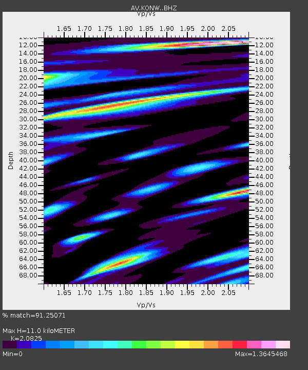
KONW Northwest, Korovin Volcano, Alaska - Earthquake Result Viewer
| Earthquake location: |
Kermadec Islands, New Zealand |
| Earthquake latitude/longitude: |
-29.7/-177.3 |
| Earthquake time(UTC): |
2021/03/04 (063) 19:28:31 GMT |
| Earthquake Depth: |
19 km |
| Earthquake Magnitude: |
8.1 mww |
| Earthquake Catalog/Contributor: |
NEIC PDE/us |
|
| Network: |
AV Alaska Volcano Observatory |
| Station: |
KONW Northwest, Korovin Volcano, Alaska |
| Lat/Lon: |
52.40 N/174.21 W |
| Elevation: |
334 m |
|
| Distance: |
81.8 deg |
| Az: |
1.891 deg |
| Baz: |
182.684 deg |
| Ray Param: |
0.047299728 |
| Estimated Moho Depth: |
11.0 km |
| Estimated Crust Vp/Vs: |
2.08 |
| Assumed Crust Vp: |
5.88 km/s |
| Estimated Crust Vs: |
2.824 km/s |
| Estimated Crust Poisson's Ratio: |
0.35 |
|
| Radial Match: |
91.25071 % |
| Radial Bump: |
400 |
| Transverse Match: |
79.23787 % |
| Transverse Bump: |
400 |
| SOD ConfigId: |
23341671 |
| Insert Time: |
2021-03-18 20:46:47.540 +0000 |
| GWidth: |
2.5 |
| Max Bumps: |
400 |
| Tol: |
0.001 |
|

Signal To Noise
| Channel | StoN | STA | LTA |
| AV:KONW: :BHZ:20210304T19:40:18.059978Z | 1.8017981 | 3.7812351E-6 | 2.0985897E-6 |
| AV:KONW: :BHN:20210304T19:40:18.059978Z | 1.1980613 | 1.8981248E-6 | 1.5843302E-6 |
| AV:KONW: :BHE:20210304T19:40:18.059978Z | 1.1193103 | 1.9088054E-6 | 1.7053407E-6 |
| Arrivals |
| Ps | 2.1 SECOND |
| PpPs | 5.7 SECOND |
| PsPs/PpSs | 7.7 SECOND |


