You are here: Home > Network List > AV - Alaska Volcano Observatory Stations List
> Station MTBL Table Top, Makushin Volcano, Alaska > Earthquake Result Viewer
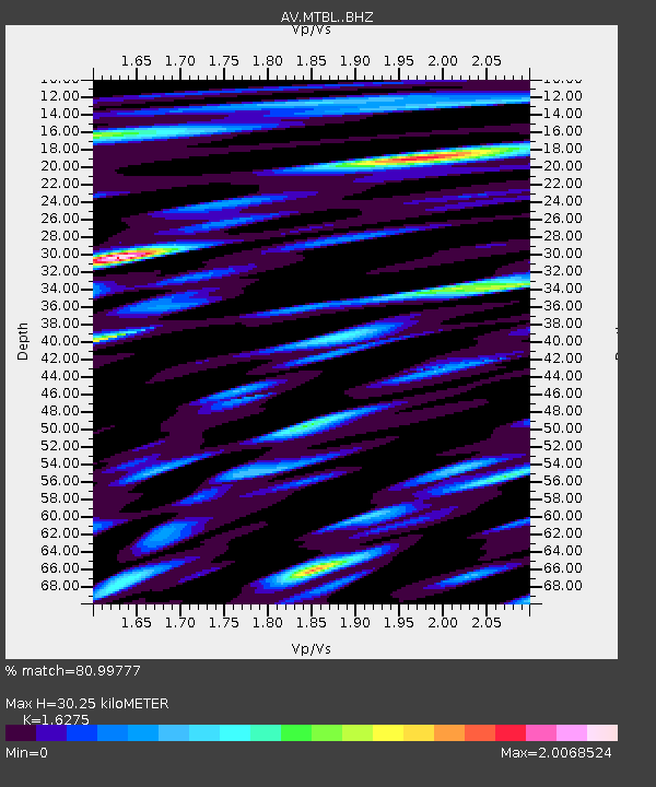
MTBL Table Top, Makushin Volcano, Alaska - Earthquake Result Viewer
| Earthquake location: |
Kermadec Islands, New Zealand |
| Earthquake latitude/longitude: |
-29.7/-177.3 |
| Earthquake time(UTC): |
2021/03/04 (063) 19:28:31 GMT |
| Earthquake Depth: |
19 km |
| Earthquake Magnitude: |
8.1 mww |
| Earthquake Catalog/Contributor: |
NEIC PDE/us |
|
| Network: |
AV Alaska Volcano Observatory |
| Station: |
MTBL Table Top, Makushin Volcano, Alaska |
| Lat/Lon: |
53.97 N/166.68 W |
| Elevation: |
810 m |
|
| Distance: |
83.9 deg |
| Az: |
6.267 deg |
| Baz: |
189.247 deg |
| Ray Param: |
0.045869954 |
| Estimated Moho Depth: |
30.25 km |
| Estimated Crust Vp/Vs: |
1.63 |
| Assumed Crust Vp: |
3.943 km/s |
| Estimated Crust Vs: |
2.423 km/s |
| Estimated Crust Poisson's Ratio: |
0.20 |
|
| Radial Match: |
80.99777 % |
| Radial Bump: |
400 |
| Transverse Match: |
81.05576 % |
| Transverse Bump: |
400 |
| SOD ConfigId: |
23341671 |
| Insert Time: |
2021-03-18 20:46:55.511 +0000 |
| GWidth: |
2.5 |
| Max Bumps: |
400 |
| Tol: |
0.001 |
|

Signal To Noise
| Channel | StoN | STA | LTA |
| AV:MTBL: :BHZ:20210304T19:40:28.579021Z | 2.8146803 | 3.7833183E-6 | 1.3441378E-6 |
| AV:MTBL: :BHN:20210304T19:40:28.579021Z | 0.86015725 | 2.6446871E-6 | 3.0746553E-6 |
| AV:MTBL: :BHE:20210304T19:40:28.579021Z | 1.2011006 | 3.491785E-6 | 2.9071546E-6 |
| Arrivals |
| Ps | 4.9 SECOND |
| PpPs | 20 SECOND |
| PsPs/PpSs | 25 SECOND |


